
Copyright © Hans Högman 2019-06-09


pop./km2 = Population per square km.
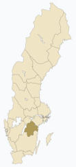
Blekinge
Blekinge, province in the south of
Sweden; area 2,941 km2 (1,136 sq mi),
population 159,684 (2018).
Blekinge is bounded in the
south and in the east by the
Baltic Sea, in the north by
the province of Småland and in the west
by the province of Skåne.
Blekinge is the second smallest Swedish
province, after Öland. Blekinge
correspond exactly to the County of
Blekinge.
When the border lines between
Denmark and Sweden was drawn during the Viking
Age Blekinge fell into Danish hands. Blekinge has
been battleground for many wars between Sweden
and Denmark.
Blekinge was ceded to Sweden by Denmark in 1658
accordingly to the peace treaty of Roskilde after the
Swedish-Danish war 1657 - 1658.
Major cities: Karlskrona and Karlshamn.
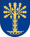
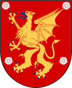
The province’s coat of arms is represented with a
golden oak on a blue setting.
The oak is also the province tree of Blekinge and
mullein the province flower.
Bohuslän
Bohuslän, province of the Swedish west
coast, area 4,473 km2 (1,727 sq mi),
population 305,212 (2018).
The province stretches 160
km from the Norwegian
border in the north and
down to the City of Gothenburg
(Göteborg) in the south. It is a narrow
province, only 40 km at its widest
place.
Bohuslän is bounded in the west by
the Skagerrack Sea, in the east by the
provinces of Dalsland and
Västergötland, in the south by Gothenburg and in
the north by Norway. The Götaälv River forms a
natural border to Västergötland.
Within the province there are 3,000 islands and
4,500 rocky islets and skerries.
Bohuslän initially belonged to Denmark but was
ceded to Sweden in 1658 according to the peace
treaty of Roskilde after the Swedish-Danish war
1657 - 1658.
Major cities: Uddevalla and Strömstad.
The province’s coat of arms is represented with a
red fortress with two golden gates encircled by a
blue lion and a blue sword. The province flower is
the honeysuckle and the harbor seal (knubbsäl) is
the province animal.
Dalarna
Dalarna, province in the western parts
of central Sweden, area 29,086 km2
(11,230 sq mi), population 283,757
(2018).
The province stretches
from the Norwegian
border in the west to almost the town
of Gävle, by the Gulf of Bothnia in the
east. Dalarna is bounded in the west
by Norway, in the north by the
province of Härjedalen, in the south by
the provinces of Västmanland and
Värmland and in the east by the
provinces of Hälsingland and
Gästrikland.
The borders of the province mostly coincide with the
County of Dalarna. The northern and western parts
of the province are mountainous areas with a lot of
ski resorts such as Sälen.
Major lakes and rivers; Dalälven River and Lake
Siljan.
The province is often referred to as the province of
Dalecarlia in articles written in English.
A famous symbol of the province is the
Dalecarlian horse, in Swedish Dalahäst, a
painted and decorated wooden horse.
The word "Dalarna" means "the dales"
(valleys).
Major cities: Falun and Borlänge.
The province’s coat of arms is represented with two
crossed arrows . The province flower is the
"ängsklocka" and the eagle owl or the great horned
owl (US) (berguv) is the province animal.
Dalsland
Dalsland, province in the northwestern
parts of Götaland, area 3,715 km2
(1,434 sq mi), population 50,593 (2018).
It is bounded in the east
by Lake Vänern, to the
west by Norway and the
province of Bohuslän, in the north by
the province of Värmland and in the
south by the province of Västergötland.
Dalsland is one of the smaller
provinces in Sweden. It is only 99 km
(66 mi) from north to south and 59 km
(37 mi) from west to east.
Major city: Åmål.
Major lakes; Lake Värnern.
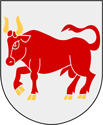
The province’s coat of arms is represented with a
heraldic bull .
The province flower is the forget-me-not and the
raven (korp) is the province animal.
Gotland
Gotland, an island and a province in the
Baltic Sea, in the southeastern parts of
Sweden, area 3,183 km2 (1,229 sq mi),
population 52,249 (2018).
It is about 100 km (62 mi) from the
island of Gotland to the mainland of
Sweden.
The province of Gotland coincide with
the county of Gotland. Beside the major
island of Gotland there are a few other
larger and smaller islands belonging to
the province; Fårö, Gotska Sandön, Stora
Karlsö and Lilla Karlsö. Gotland
stretches 125 km (78 mi) from north to
south and 52 km (32 mi) from east to
west. It is Sweden's largest island.
Gotland is a seaside resort and its
population increases greatly during summer.
Major city: Visby.
The province coat of arms is represented with a
ducal coronet. Blazon: "Azure a ram statant Argent
armed Or holding on a cross-staff of the same a
banner Gules bordered and with five tails of the
third.
The province flower is the ivy and the hedgehog is
the province animal.
Gästrikland
Gästrikland, province in the southern
parts of Norrland, area 4,181 km2
(1,614 sq mi), population 155,697
(2018).
Gästrikland is bounded in
the south by the province
of Uppland, in the west by the
provinces of Västmanland and Dalarna,
in the north by the province of
Hälsingland and in the east by the Gulf
of Bothnia and the Baltic Sea.
Gästrikland is a forested province, 75%
of its area is covered by forestland.
Evergreens is the dominating type of
trees; spruce and pine trees. Major
rivers; Dalälven River.
Major cities: Gävle and Sandviken.
The province’s coat of arms is represented with an
elk (US: moose).
The province flower is the lily of the valley and the
capercaillie (tjäder) is the province animal.
Halland
Halland, province in the southwestern
parts of Sweden, area 4,796 km2 (1,852
sq mi), population 327,093 (2018).
Halland is bounded in the
south by Skåne, in the
east by provinces Småland
and Västergötland, in the north by
Västergötland and in the west by the
Cattegat Sea.
The province of Halland mostly
coincide with the County of Halland.
In the 12th century Halland belonged
to Denmark. Denmark ceded Halland
to Sweden for 30 years in the peace
treaty of Brömsebro in1645. However, Halland
permanently became Swedish territory in the peace
treaty of Roskilde after the Swedish-Danish war
1657 - 1658.
Major cities: Halmstad and Varberg.
The province’s coat of arms is represented with an
upraised silver lion on a blue setting.
The province flower is the hairy greenweed and the
salmon (lax) is the province animal.
Hälsingland
Hälsingland, province in the southern
parts of Norrland, area 14,264 km2
(5,507 sq. miles), population 131,322
(2018).
Hälsingland is bounded in
the south by the province of
Gästrikland, in the west by the
provinces of Dalarna and Härjedalen,
in the north by the province of
Medelpad and in the east by the Gulf
of Bothnia.
Major cities: Hudiksvall, Söderhamn
and Bollnäs.
Hälsingland is a forested province, 83%
of its area is covered by forestland.
Evergreens is the dominating type of trees, primarily
spruce and pine.
Hälsingland is sometimes referred to as Helsingia in
English.
The province’s coat of arms is represented with a
he-goat on a black setting.
The province flower is the flax flower (linblomma)
and the lynx (lo) is the province animal.
Härjedalen
Härjedalen, province in the
southwestern parts of Norrland, area
11,954 km2 (4,615 sq. miles),
population 9,677 (2018).
Härjedalen is bounded in
the south by the province of Dalarna, in
the west by Norway, in the north the
province of Jämtland and in the east by
the provinces of Hälsingland and
Medelpad.
Mountains and forestland characterize
Härjedalen and there are a lot of ski
resorts in the province.
During the Danish-Norwegian period
Härjedalen belonged to the Nidaros
archbishop's diocese in Norway. Around 1450
Härjedalen was under Swedish rule. Denmark ceded
Härjedalen to Sweden in the peace of Brömsebro in
1645.
The province’s coat of arms is represented with
tools for iron ore work.
The province flower is the pasque-flower (mosippa)
and the bear (björn) is the province animal.
Jämtland
Jämtland, province in the western parts
Norrland, area 34,009 km2 (13,131 sq
mi), population 117,068 (2018).
Jämtland is bounded in the
south by the province of
Härjedalen, in the west by
Norway, in the north the province of
Lappland and in the east by the
provinces of Medelpad and
Ångermanland.
The province is by large a mountainous
province with a lot of ski resorts of
which Åre is one of the best known. The
land rises in the west up to 1,762 m
(5,780 ft) but falls to below 500 m (1,500 ft) in the
east.
Jämtland is by area the second largest province in
Sweden.
Major city: Östersund.
In the 12th century Jämtland belonged to Norway
and later Denmark/Norway. Denmark ceded
Jämtland to Sweden in the peace treaty of
Brömsebro in1645.
The province’s coat of arms is represented with a
hunting subject with a gyrfalcon and an elk (US:
moose). The province flower is the "brunkulla" and
the elk/moose (Swe: Älg) is the province animal.
Lappland
Lappland, province in the northwestern
part Norrland, area 109,702 km2 (42,356
square miles), population 90,674 (2018).
Lappland is bounded in the
south by the province of
Jämtland, in the west and
north by Norway, in the northeast by
Finland and in the east by the provinces
of Ångermanland, Västerbotten and
Norrbotten.
The province is by large a mountainous
region with a lot of ski resorts. Dundret,
Tärnaby, Abisko, Björkliden, and
Riksgränsen are well-known winter-
sports resorts.
The highest mountains in Sweden, notably Mounts
Kebne (Kebnekaise - 2,111 m (6,926 feet)) and Sarek
(2,089 m (6,854 feet)) is located in Lappland.
Lappland is by area the largest province and covers
about one-fourth of the total area of Sweden, but it
is sparsely settled. Lappland is extending above the
Arctic Circle.
Lappland is often referred to as Lapland in English.
Major city: Kiruna.
Having incorporated more than 20,669 km2 (7,980
square miles) in 1948, Kirurna claimed to be the
world's largest city by area.
The province’s coat of arms is represented with a
Stone-Age man. The province flower is the mountain
avens (fjällsippa) and the arctic fox (fjällräv) is the
province animal.


Provinces of Sweden
Medelpad
Medelpad, province in the
central/eastern parts of Norrland, area
7,058 km2 (2,725 sq mi), population
126,323 (2018).
Medelpad is bounded in the
south by the province of
Hälsingland, in the west by the
provinces of Härjedalen and Jämtland,
in the north the province of
Ångermanland and in the east by the
Gulf of Bothnia.
Medelpad is a forested province, 70% of
its area is covered by forest. Evergreens
is the dominating type of trees,
primarily spruce.
Two major rivers flows through Medelpad, The
Ljungan River and the Indalsälven River.
Until the 14th century Medelpad as well as
Ångermanland was a part of the province of
Hälsingland. Medelpad is first mentioned in the
sources as an independent area in 1374.
Major city: Sundsvall.
The province’s coat of arms is represented with a
topographical motive, two silver streams
representing the two rivers of Medelpad. The
province tree is the spruce (gran) and the mountain
hare (skogshare) is the province animal.
Norbotten
Norrbotten, province in the
northeastern part of Norrland, area
26,671 km2 (10,298 sq mi), population
195,746 (2018).
Norrbotten is bounded in
the south by the province of
Västerbotten, in the west by the
province of Lappland, in the northeast
by Finland and in the east by the Gulf of
Bothnia.
By tradition Norrbotten has been a part
of the province of Västerbotten and not
really an independent province.
However, when the County of
Västerbotten was divided into two counties in 1810,
Västerbotten and Norrbotten, the part of the
province of Västerbotten that resided in the new
county of Norrbotten then was regarded as an
province with the same name.
Not being one of the old historical provinces of
Sweden Norrbotten have not been granted a coat of
arms, an escutcheon, in the same way as the others.
As recent as 1995, after decades of controversy,
Norrbotten got its arms, thus recognized as a "real"
province.
Major cities: Luleå and Piteå.
The province flower is the arctic raspberry (åkerbär)
and the Siberian jay (lavskrika) is the province animal.
Närke
Närke, province in the central part of
Svealand, area 4,126 km2 (1,593 sq mi),
population 216,186 (2018).
Närke is bounded in the
southwest by the province of
Västergötland, in the
northwest by the province of Värmland, in
the north by province of Västmanland, in
the east by the province of Södermanland
and in the southeast by the province of
Östergötland. Närke adjoins Lake Vättern
in the south.
Major cities: Örebro and Karlskoga.
The province’s coat of arms is represented with two
crossed arrows and roses. The province flower is the
cowslip (gullviva ) and the dormouse (hasselmus) is
the province animal.
Skåne
Skåne, province in the extreme south of
Sweden, area 10,939 km2 (4,224 sq mi),
population 1,359,800 (2018).
Skåne is bounded in the
north by the provinces of
Halland and Småland, in
the northeast by the province of
Blekinge, in the south and west by the
Baltic Sea, in the west by the Sound
(Öresund) and in the northwest by the
Cattegat Sea. The islands of Hallands
Väderö and Ven also belongs to Skåne.
The province's countryside is plains.
Skåne initially belonged to Denmark but was ceded
to Sweden in 1658 in accordance with the peace
treaty of Roskilde after the Swedish-Danish war 1657
- 1658. The province is often referred to as the
province of Scania in articles written in English.
Major cities: Malmö, Hälsingborg and Lund.
The Öresund Bridge (Öresundsbron) connects
Sweden and Denmark, or to be more exact the cities
of Malmö in Sweden and Copenhagen in Denmark.
The total length of the Öresund Bridge is 7.845 m
(4.87 miles).
The province’s coat of arms is represented with a
red griffin head with a blue crown and blue beak and
tongue. The province flower is the ox-eye daisy
(prästkrage ) and the red deer (kronhjort) is the
province animal.
Småland
Småland, province in southern Sweden
(central part of Götaland), area 29,330
km2 (11,324 sq mi), population 769,556
(2018).
Småland is bounded in the
north by the province of
Östergötland and by Lake Vättern, in
the south by the provinces of Blekinge
and Skåne, in the west by the provinces
of Västergötland and Halland and in the
east by the Baltic Sea.
Småland is a part of three different
counties; the counties of Jönköping,
Kalmar and Kronoberg.
Major cities: Kalmar, Jönköping and Växjö.
Major lakes; Lake Vättern.
Småland is a forested province. Evergreens is the
dominating type of trees. The central part of the
province is highland.
The province’s coat of arms is represented with an
upraised red lion on a golden setting. The lion is
holding a red cross-bow and an arrow with a silver
arrow-head in his paws.
The province flower is the twinflower (linnea ) and
the red otter (utter) is the province animal.
Södermanland
Södermanland or Sörmland, province in
the eastern part of Svealand, area 8,169
km2 (3,154 sq mi), population 1,320,477
(2018).
Södermanland is bounded
in the north by the province
of Uppland and by Lake Mälaren, in the
south by the province of Östergötland,
in the west by the province of Närke, in
the northwest by the province of
Västmanland and in the east by the
Baltic Sea.
The province of Södermanland is mostly
coincide with the County of
Södermanland. However, the
northeastern part of the province is attached to the
Stockholm County.
The border line between provinces Södermanland
and Uppland goes through central Stockholm
(through the Old Town).
Södermanland is a forested province, 65% of its area
is covered by forest. Evergreens is the dominating
type of trees.
Major cities: Nyköping, Södertälje, Strängnäs and
Eskilstuna.
Major lakes; Lake Mälaren.
The province’s coat of arms is represented with a
black griffin on a golden setting. A griffin is a heraldic
fabulous animal with a forepart of the body as an
eagle and the abdomen of a lion.
The province flower is the white water-lily (vit
näckros) and the fish hawk (fiskgjuse) is the province
animal.
Uppland
Uppland, province in the eastern part of
Svealand, area 12,676 km2 (4,894 sq mi),
population 1,660,424 (2018).
Uppland is bounded in the
north by the province of
Gästrikland, in the south by
the province of Södermanland and by
Lake Mälaren, in the west by the
province of Västmanland and in the east
by the Baltic Sea.
The province of Uppland largely coincide
with the County of Uppsala. The border
line between Uppland and
Södermanland goes through central
Stockholm (through the Old Town).
The northern part Uppland is a forested area while
the central and southern part are plains.
Major cities: Uppsala and Norrtälje.
Major lakes; Lake Mälaren.
The province’s coat of arms is represented with a
golden orb on a red setting.
The province flower is the snake's head
(kungsängslilja ) and the sea-eagle (havsörn) is the
province animal.
Värmland
Värmland, province in the western part
of Svealand, area 18,204 km2 (7,029 sq
mi), population 320,436 (2018).
Värmland is bounded in the
north by the province of
Dalarna, in the south by the
provinces of Västergötland and by
Dalsland, in the southeast by Lake
Vänern, in the west by Norway and in
the east by the provinces of
Västmanland and Närke.
The province of Värmland is in large
coextensive with the county of
Värmland.
Major cities: Karlstad, Kristinehamn and Arvika.
Värmland is a forested province, especially the
northern part. About 60% of its area is covered by
forest. Evergreens is the dominating type of trees;
spruce and pine trees.
Major lakes; Lake Värnern.
The province’s coat of arms is represented with an
eagle.
The province flower is the chickweed wintergreen
(skogsstjärna ) and the wolf (varg) is the province
animal.
Västerbotten
Västerbotten, province in the
northeastern parts of Norrland, area
15,538 km2 (5,999 sq mi), population
224,663 (2018).
Västerbotten is bounded in
the south by the province of
Ångermanland, in the west by the
province Lappland, in the north the
province of Norrbotten and in the east
by the Gulf of Bothnia and the Kvarken
straits.
Major cities: Umeå and Skellefteå.
The province’s coat of arms is
represented with a silver reindeer.
The province flower is the "kung Karls spira" and the
curlew (storspov) is the province animal.
Västergötland
Västergötland, province in the western
part of Götaland, area 16,676 km2 (6,439
sq mi), population 1,361,326 (2018).
Västergötland is bounded in
the south by the province of
Halland, in the west by the
provinces of Bohuslän and Dalsland and
by the Cattegat Sea, in the north the
provinces of Värmland and Närke and by
the Lake Vänern and in the east by the
provinces of Östergötland, Småland and
by Lake Vättern.
Västergötland is a part of three different
counties; the counties of Västra Götaland, Halland
and Örebro.
The province is a farming province with plains,
especially in the northwest.
Major cities: Göteborg, Borås and Skara.
Major lakes; Lake Värnern.
The province’s coat of arms is represented with a
lion surrounded by stars.
The province flower is the heather (ljung) and the
crane (trana) is the province animal.
Västmanland
Västmanland, province in the central
parts of Svealand, area 8,363 km2 (3,229
sq mi), population 315,000 (2018).
Västmanland is bounded in
the south by the provinces
of Södermanland and
Närke, in the west by the province of
Värmland, in the north by province of
Dalarna, in the east by the province of
Uppland.
The province of Västmanland mostly
coincide with the County of
Västmanland.
Major cities: Västerås and Sala.
Major lakes; Lake Mälaren.
The province’s coat of arms is represented with
three mountain peaks. From each of the peaks there
are flames of fire.
The province flower is the mistletoe (mistel) and the
roe deer (rådjur) is the province animal.
Ångermanland
Ångermanland, province in the
central/eastern parts of Norrland, area
19,800 km2 (7,645 sq mi), population
131,499 (2018).
Ångermanland is bounded in
the south by the province of
Medelpad, in the west by the provinces
of Jämtland and Lappland, in the north
the province of Västerbotten and in the
east by the Gulf of Bothnia.
Major cities: Härnösand, Örnsköldsvik
and Sollefteå.
Ångermanland is a forested province.
Evergreens is the dominating type of
trees, primarily spruce.
A major river is flowing through the province; the
Ångermanälven River.
Until the 14th century Medelpad as well as
Ångermanland was a part of the province of
Hälsingland. Ångermanland is first mentioned in the
sources as an independent province in 1300's.
The province’s coat of arms is represented with
three salmons.
The province flower is the love-in-idleness
(styvmorsviol ) and the beaver (bäver) is the province
animal.
Öland
Öland, province and an island in the
eastern parts of Götaland, area 1,347
km2 (520 sq mi), population 25,921
(1999).
Öland is an island and by
area the smallest province
in Sweden. It is bounded in the east by
the province of Småland, surrounded by
the Baltic Sea.
The island is 135 km long and between
6 to 15 km wide. Öland is a seaside
resort and its population increases
many times during summer.
Major city: Borgholm.
The Öland Bridge connects the city of Kalmar with
the town Färjestaden in Öland. The total length of
the bridge is 6,072 m (3.77 miles).
The province’s coat of arms is represented with a
red deer (Cervus elaphus).
The province flower is the "ölandssolvända" and the
thrush nightingale (näktergal) is the province animal.
Östergötland
Östergötland, province
in the northeastern parts
of Götaland, area 9,979
km2 (3,853 sq mi),
population 459,589
(2018).
Östergötland is bounded in the north
by the provinces of Södermanland and
Närke, in the south by the province of
Småland, in the west by the province
of Västergötland and by Lake Vättern and Halland
and in the east by the Baltic Sea.
Major cities: Linköping, Norrköping and Motala.
The area of the province is more or less identical to
the one of the County of Östergötland.
The province has forested regions in the north as
well as in the south. In between these regions there
are plains.
About 60% of its area is covered by forest.
Evergreens is the dominating type of trees.
The province’s coat of arms is represented with a
griffin with wings of a dragon plus roses.
The province flower is the cornflower (blåklint ) and
the mute swan (knölsvan) is the province animal.


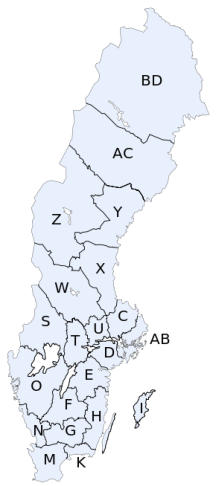
Maps
Map, Swedish Counties
Map, Swedish
Provinces
Map, Swedish
Lands
Map, Swedish County
Codes
Information about the Swedish
Provinces
Introduction
Beside the counties, Sweden is also divided into a
number of provinces. The subdivision of counties
was introduced in 1634 but the provinces are much
older, from early medieval times. The provinces are
historical, geographical and cultural regions and have
no administrative or political function but remain
historical legacies and the means of cultural
identification.
The provinces are still used in colloquial speech and
cultural references and can therefore not be
regarded as an archaic concept.
In addition, the administrative regional units - the
counties - are subject to continuous changes while
the provinces have had their historical borders
outlined for centuries. There are 25 provinces.
In some cases, the administrative counties
correspond almost exactly to the provinces, as is
Blekinge to Blekinge County. In other cases, they do
not, which then enhances the cultural importance of
the provinces. The provinces play an important role
in people's self-identity and If you ask a Swede were
he lives he most likely would say the name of "his"
province rather than the county.
The Swedish term for province is “Landskap”.
English and other languages occasionally use Latin
names as alternatives to the Swedish names. The
name Scania for Skåne predominates in English.
Swedes writing in English have long used Swedish-
language name forms only. The province of Lappland
is known as Swedish Lapland in English.
See also The subdivisions of Sweden into Lands,
Provinces and Counties
There are a lot of references
to the Swedish lands and
counties in the information
about each province below.
See the maps of the
provinces, lands and counties
at the end of this webpage
for better understanding of
each province's location.
The provinces in the listing
below are ordered in
alphabetical order.
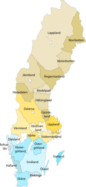
The map shows the different
provinces of Sweden. See the
bottom of this page for a
larger resolution of this map.
Provinces:

Contents this page: