A short description of the States where the majority of Swedish immigrants settled.
States, Counties and Townships
State:The primary political unit of the United States is the State. The 50 individual states and the United States as a whole are each sovereign jurisdictions. In all of the U.S. states, the chief executive is called the Governor. The legislatures of 49 of the 50 states are made up of two chambers: a lower house (termed the House of Representatives, State Assembly or House of Delegates) and a smaller upper house, always termed the Senate. The exception is the unicameral Nebraska Legislature, which is composed of only a single chamber. States can also organize their judicial systems differently from the federal judiciary, as long as they protect the federal constitutional right of their citizens to procedural due process. There are in the United States both federal laws and State laws.Because of the shared sovereignty between each U.S. state and the U.S. federal government, an American is a citizen of both the federal republic and of his or her state of domicile.Kentucky, Massachusetts, Pennsylvania, and Virginia use the official title of Commonwealth rather than State. The term has no legal impact.New England is not a state but a region in the northeastern corner of the United States consisting of the six states of Maine, Massachusetts, New Hampshire, Vermont, Rhode Island, and Connecticut.County:The states are divided into smaller administrative regions, called counties in all but two states, which may be assigned some local governmental authority but are not sovereign. The exceptions are Alaska where the main subdivision is the boroughs and Louisiana which is divided into county-equivalents that are called parishes. County or county-equivalent structure varies widely by state. Counties may contain a number of cities, towns, villages, or sometimes just a part of a city. Some cities are consolidated with, and coterminous with, their counties. Some states contain independent cities that are not part of any county. New York City is coterminous with five counties.A consolidated city-county is a city and county that have been merged into one unified jurisdiction. As such it is simultaneously a city, which is a municipal corporation, and a county, which is an administrative division of a state. It has the powers and responsibilities of both types of entities. An American consolidated city-county corresponds to the Swedish “kommun which is the entity for local administration in Sweden.Township:Towns and townships are subdivisions of counties. However, the powers granted to towns or townships vary considerably from state to state. Some townships have governments and political power, others are simply geographic designations.Towns or townships are used as subdivisions of a county in 20 states, mostly in the Northeast and Midwest.
States where the majority of Swedish immigrants settled
Below is a short description of the States where the majority of Swedish immigrants settled:
The Emigration from Sweden to the USA (7e)
Illinois
Illinois is the runner up behind Minnesota in terms of number of Swedish settlers. The Illinois Territory was created on February 3, 1809, with its capital at Kaskaskia, an early French settlement. In 1818, Illinois became the 21st U.S. state. In 1837 the capital was moved to Springfield.The largest city in Illinois is Chicago, the third most populous city in the United States with 2.7 million residents. Chicago was incorporated as a city in 1837 between the Great Lakes and the Mississippi River watershed. Chicago is located at one of few natural harbors in southern Lake Michigan. Though Illinois lies entirely in the Interior Plains, it does have some minor variation in its elevation and its highest point is Charles Mound at 1,235 ft (376 m). Illinois' rich prairie’s major agricultural outputs are corn, soybeans, hogs, cattle, dairy products, and wheat.Because of its nearly 400-mile (644 Km) distance between its northernmost and southernmost extremes, as well as its mid-continental situation, Illinois has a widely varying climate. Most of Illinois has a humid continental climate with hot, humid summers and cold winters. The southernmost part of the state borders on a humid subtropical climate, with more moderate winters. Average yearly precipitation for Illinois varies from just over 48 inches (1,219 mm) at the southern tip to around 35 inches (889 mm) in the northern portion of the state. Normal annual snowfall exceeds 38 inches (965 mm) in the Chicago area. Summer high temperatures averages between 77 and 88 F (25 – 32 C) while winter temperatures are below freezing except for the southernmost parts which have milder winters.Illinois total area is 57,914 sq mi (149,998 km2) and its width is 210 miles (340 km) and its length is 395 miles (629 km). Illinois' rich prairies have attracted great deals of immigrant farmers from Germany and Sweden.
Chicago
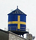
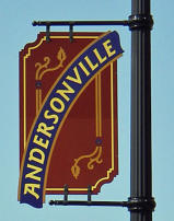
Chicago is the third most populous city in the United States, after New York City and Los Angeles with 2.7 million residents. Its metropolitan area, sometimes called Chicagoland, is home to 9.5 million people. The population of Illinois is 12,882,000 (2013 est) with the majority of its residents living in Chicagoland. Chicago is the seat of Cook County in the northeastern corner of Illinois by Lake Michigan.With a population of 350 Chicago was incorporated as a city in 1837. Large parts of the city were destroyed in a fire in 1871. Chicago was the largest “Swedish” city in the United States. In 1900 there were more Swedes living in Chicago than Gothenburg, Sweden and Chicago counted 40 Swedish churches. In 1910 Chicago had about 110,000 Swedish inhabitants. The city’s Swedish heritage can still be seen in the neighborhood of Andersonville in western Edgewater, northern parts of Chicago around North Clark Street and West Foster Avenue. Andersonville was once a little village made up primarily of Swedish immigrants. Today Swedish cultural presence is led by the Swedish American Museum, the Swedish Bakery and other Swedish businesses. Many of Andersonville's Swedes were carpenters, contractors and architects, and played a significant role in building the city. There is a water towerthat sits atop the Swedish American Museum in Andersonville painted in the colors of the Swedish flag, yellow cross on a blue background. See image to the left.
Rockford
Rockford, Winnebago County, Illinois, has a large number of Swedish descendants. Between a third and half of the 150,000 residents of Rockford have Swedish roots from places such as Öland, Småland and Blekinge provinces and the city is characterized by its South Swedish heritage. Rockford is a city located on the east and west banks of the Rock River in far northern Illinois and referred to as "The Forest City". Rockford is the county seat of Winnebago County. Rockford was well known for its elm trees, being the reason for its nickname, the Forest City. According to the 2010 U.S. census, the city was home to 152,871 people.Rockford was first settled in 1834–1835 and the settlement was incorporated as a village in 1839, and chartered as a city in 1852. The location got its name Rockford, because of the excellent ford across the Rock River. In 1852 the Galena and Chicago Union Railroad reached the city. By 1860 Rockford had become a significant, growing industrial center.The Swedes primarily settled on the eastern side of the Rock River in Rockford. In 1876, the Rockford Union Furniture Company was established by a group of Swedes led by John Erlander, an immigrant from Småland, Sweden. It was the first of 25 area furniture factories that were formed as cooperatives. By the 1880's the furniture industry was using the talents of Swedish-born craftsmen and financiers, and by the first half of the 20th century Rockford was the second largest furniture manufacturing center in the United States. Still existing today is the Swedish-American Hospital. The hospital is owned and operated by the Swedish American Health System. The hospital was founded in 1911 and opened its doors in 1918.The Erlander Home Museum is the site of the Swedish Historical Society of Rockford. It is located in what was the home of Swedish immigrant John Erlander, former president of the Rockford Union Furniture Company. The Lake-Peterson House, formerly the home of Swede Pehr August Peterson, is listed on the U.S. National Register of Historic Places. Peterson was the founder of the Swedish-American Hospital and a co-founder of the Rockford Union Furniture Company together with John Erlander. The Lake-Peterson House was built in 1873 and is owned and maintained by Swedish American Hospital in Rockford. Peterson bequeathed half a million dollars to a home designed for elderly Swedes in Rockford, the P. A. Peterson Home for the Aged, which was opened in 1941. At Rock Valley College there is Bengt Sjostrom Theater, an outdoor theater.
Minnesota is a state in the Upper Midwest. The largest city in Minnesota is Minneapolis but Saint Paul is the state capital. Saint Paul is adjacent to Minneapolis and they are known collectively as the “Twin Cities”. Minneapolis is located along the banks of the Mississippi River just north of the river’s confluence with the Minnesota River. The population of Minneapolis is 392,880 (2012) and is located in Hennepin County. The population of Saint Paul is 290,770 (2012) and is located in Ramsey County.The portion of the state east of the Mississippi River became part of the United States at the end of the American Revolutionary War (1775 – 1783). Land west of the Mississippi River was acquired with the Louisiana Purchase (1803 – 1804). Minnesota Territory was formed on March 3, 1849. Thousands of people had come to build farms and cut timber, and Minnesota became the 32nd U.S. state on May 11, 1858.Fort Snelling was constructed between 1820 and 1824. It was originally known as Fort Saint Anthony, and was a military fortification located at the confluence of the Minnesota River and the Mississippi River in Hennepin County, Minnesota. The first permanent settlements arose at that time.The railroad between Chicago and Minneapolis was opened in 1867 which made it easier for immigrants to arrive in Minnesota. The state of Minnesota is the state where most Swedish immigrants settled having a large share of Swedes and other Scandinavians. Minnesota's nickname is The Land of 10,000 Lakes since there are many lakes in the state. The highest point is Eagle Mountain at 2,302 ft (701 m). There are several mountain chains west of Lake Superior stretching in a southwestern direction. West and south of this region are extended areas of prairie with fertile loess. Minnesota is divided into 87 counties. The population of Minnesota is 5,420,380 (2013 est.).Together with Minnesota the states North Dakota, South Dakota and Wisconsin makes up the region Upper Midwest which is a part of the Midwest. The area of Minnesota is 86,939 sq. mi (225,181 km2) which constitutes 2.25% of the United States’ total area. As a comparison the largest province in Sweden, Lappland, covers an area of 42,356 sq mi (109,702 km2).Minnesota’s width is 200–350 miles (320–560 km) and its length is 400 miles (640 km).Minnesota faces the Canadian border to the north and Lake Superior in the northeast. The climate of Minnesota is continental with large differences in temperature between summer and winter. The average January temperature is 11.3 F (-11.5 C) which makes it the coldest month of the year. The warmest month is July with an average temperature of 73 F (23 C). The average annual precipitation is 28 in (719 mm).
Chisago County, MN
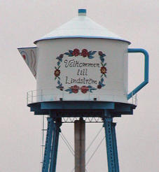
Chisago County is a county in Central East Minnesota about 35 miles (55 km) north-east of Saint Paul and faces Wisconsin on its eastern side. As of the 2010 census, the population was 53,887. Its county seat is Center City which has a population of 500. The major cities are Lindstrom with a population of 4,500 (2010) and Chisago City with about 5,000 residents (2010).Chisago County is like many other counties in Minnesota strongly influenced by Swedish immigrants and a county where an overwhelmingly amount of Swedish immigrants settled during the second half of the 1800’s. It was here where Vilhelm Moberg did his research for his The Emigrants suite in the 1950's.Chisago City: Chisago City is located between the twin lakes of Chisago Lake and Green Lake, and is part of the Chisago lakes region. The city was founded by Swedish immigrants in the 1850's. It was originally settled one mile south, but when the railroad bypassed the town in 1880, the city moved closer to the railroad, as often happened during that time.The city is located approximately 35 miles (55 km) northeast of downtown Minneapolis–Saint Paul. Vilhelm Moberg Park features the bronze statue of Vilhelm Moberg holding his bicycle for which it was named. The population was 4,967 at the 2010 census.Lindstrom:Another city in Chisago County that bears a Swedish heritage is Lindstrom. The city was founded in 1853 by Daniel Lindström from Hassela, Hälsingland province, Sweden. You see the city name spelled Lindstrom as well as Lindström. The city of Lindström was incorporated in 1894, 41 years later. Lindström was settled predominantly by Swedish immigrants and their families. The inhabitants today are largely decedents to Swedish immigrants and some elderly still speaks Swedish. Many stores in Lindstrom have Swedish names and Swedish flags hang outside the stores. Lindström's motto is America's Little Sweden. The image to the right shows Lindström's old water tower which has the shape of a typical Swedish coffee pot, a community landmark. The text on the tower is in Swedish and reads "Välkommen till Lindström" (Welcome to Lindström). The photo is a free image.The Swedish author Vilhelm Moberg visited the area in the late 1940’s to gather material for his emigrant epos, The Emigrant series. The novels are primarily about the fictitious farmer Karl-Oskar Nilsson and his wife Kristina from Ljuder parish, Småland. The fictitious family settled by Lake Ki-Chi-Saga in the novels. The name of the lake is today Lake Chisago. Lindström celebrates Karl Oskar and Kristina annually with Karl Oskar Days. This event takes place mid-July and includes such activities as the coronation of a "Karl Oskar Princess", parades, a street dance, and fireworks. There are statues of Karl Oskar and Kristina in Lindström, as a tribute to the early Swedish immigrants whose descendants continue to populate the area. Since 1990, anyone who has taken U.S. Highway 8 from north of Forest Lake to Lindström has driven on the Moberg Trail. As of the census of 2000 there were 3,015 people residing in the city. About 22.8% of the population was Swedish descendants. Lindström is located about 35 miles (55 km) north-east of Minneapolis–Saint Paul.
Mora, Kanabec County
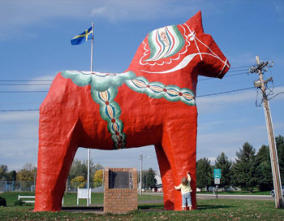
The city of Mora in Kanabec County in central Minnesota (just north of Chicago County) is another city which is influenced by its Swedish heritage. The city is the county seat and its population was 3,571 at the 2010 census.Mora received its name in 1882 from Israel Israelson (Israelsson) who together with his family had emigrated from Sweden in 1871. The name was suggested by Israelson for his home town Mora, Dalarna province, Sweden. It was first surveyed and mapped out (platted) on May 19, 1882, incorporated as a village in March 1891, and was designated a city by state statute in 1973. Mora is located 72 miles (115 Km) north of Minneapolis and St. Paul. Mora's sister city and namesake is Mora, Sweden. The image to the left shows the gigantic Dala horse in Mora, Minnesota. Notice the blue and yellow Swedish flag flying in the background. The photo is a free image.There is a gigantic Dala horse in Mora, MN, and a Mora clock commemorating the town's Swedish roots. The city of Mora also plays host each February to the Mora Vasaloppet, the largest cross-country ski race in Minnesota, the Mora Half-Marathon, and the Mora Bicycle Tour. The Vasaloppet (The Vasa race) in Sweden is an annual long distance 90 km (56 mi) cross-country ski race (ski marathon) between the village of Sälen and town of Mora held on the first Sunday in March and has about 15,000 racers. The race has a mass start, i.e. all competitors start at the same time. The race was first run in 1922, inspired by a run by King Gustav Vasa of Sweden in 1520. It is the oldest, the longest, and the biggest (in terms of participants) cross-country ski race in the world.
In colonial times, Iowa was a part of French Louisiana. After the 1803 Louisiana Purchase, Iowa was placed under United States control. The first American settlers officially moved to Iowa in June 1833. On July 4, 1838, the U.S. Congress established the Territory of Iowa. On December 28, 1846, Iowa became the 29th state in the Union.Iowa occupies an area of 56,272 sq mi (145,743 km2), its width is 310 miles (500 km) and its length is 199 miles (320 km). The population of Iowa is 3,090,416 (2013 est).The Highest point is Hawkeye Point at 1,671 ft (509 m). There are several natural lakes in the state.Iowa’s capital and largest city is Des Moines, Polk County. The city's population was 203,433 as of the 2010 census. It was founded in 1843 and incorporated on September 22, 1851, as Fort Des Moines which was shortened to "Des Moines" in 1857.Iowa's natural vegetation is tallgrass prairie and savanna in upland areas. Most of Iowa is used for agriculture; crops cover 60% of the state. The introduction of railroads in the 1850s and 1860s transformed Iowa into a major agricultural producer in the heart of the Corn Belt. Iowa's main agricultural outputs are hogs, corn, soybeans, oats, cattle, eggs, and dairy products.Many Swedish immigrants settled in the northeastern parts of Iowa.
Wisconsin
Wisconsin was first in the hands of the French but they made no permanent settlements in the area before Great Britain won control of the region following the French and Indian War in 1763. Wisconsin became a territorial possession of the United States in 1783 after the American Revolutionary War. However, the British remained in control until after the War of 1812 which finally established an American presence in the area. Wisconsin Territory was organized in 1836. Continued settlement led to statehood on May 29, 1848 (30th State).Wisconsin is located in the north-central United States, in the Midwest and Great Lakes regions. It is bordered by Lake Michigan to the east and Lake Superior to the north. Madison, Dane County, is the State capital but Milwaukee is the largest city. As of 2012, Madison had an estimated population of 240,323. According to 2010 census data, the City of Milwaukee has a population of 594,833.Wisconsin occupies an area of 65,497.82 sq mi (169,639 km2), its width is 260 miles (420 km) and its length is 310 miles (500 km). The population of Wisconsin is 5,726,398 (2012 est). The Highest point is Timms Hill at 1,951 ft (595 m).Wisconsin is known as "America's Dairyland" because it is one of the nation's leading dairy producers. Lumbering had deforested most of the state.
Michigan
Michigan is located in the Great Lakes region of the United States. The state consists of two peninsulas, the Lower Peninsula and the Upper Peninsula. The two peninsulas are separated from each other by the Straits of Mackinac, a five-mile (8 km) channel but are connected by the Mackinac Bridge. Michigan is bounded by four of the five Great Lakes, plus Lake Saint Clair. Michigan also has a great number of inland lakes and ponds. The heavily forested Upper Peninsula is relatively mountainous in the west.Michigan was first colonized by French explorers. After the defeat of France in the French and Indian War in 1762 the region came under British rule. After the American Revolutionary War it was ceded to the United States. In 1805, the Michigan Territory was formed, which lasted until it was admitted into the Union on January 26, 1837, as the 26th state. The state's highest point, in the Huron Mountains northwest of Marquette, is Mount Arvon at 1,979 feet (603 m). The highest point in the Lower Peninsula is Briar Hill at 1,705 feet (520 m). The Lower Peninsula is often noted to be shaped like a mitten. The Upper Peninsula is influenced by the numerous Scandinavian (especially Finns) and Canadian immigrants who settled the area during the lumbering and mining boom of the late 19th century.The state capital is Lansing but the largest city is Detroit (population 2013: 681,090). Michigan covers an area of 96,716 sq mi (250,493 km2). The population of Michigan is 9,895,622 (2013 est). The state is widely known as the center of the U.S. automotive industry, being home to the country’s three major automobile companies.
Nebraska
Nebraska is located on the Great Plains of the Midwestern United States.Its state capital is Lincoln but its largest city is Omaha (population 408,958 (2010)), which is on the Missouri River. The state is crossed by many historic trails such as California Trial and Oregon Trial, but it was the California Gold Rush 1848 that first brought large numbers of non-indigenous settlers to the area. On May 30, 1854, the US Congress created the Nebraska territory. The territorial capital of Nebraska was Omaha. Nebraska became the 37th state on March 1, 1867, and the capital was moved from Omaha to the center at Lancaster, later renamed Lincoln after President Abraham Lincoln. Nebraska covers an area of 77,354 sq mi (200,520 km2) and its width is 210 miles (340 km) and its length is 430 miles (690 km). The total population is 1,868,516 (2013 est). Its highest point is Panorama Point at 5,424 ft (1,654 m).During the 1870’s to the 1880’s, Nebraska experienced a large growth in population. Because so few trees grew on the prairies, many of the first farming settlers built their homes of sod.There are wide variations between winter and summer temperatures, and violent thunderstorms and tornadoes are common. The state is characterized by treeless prairie.In Omaha there was an early population of Danes and Swedes. Omaha boasted an area of the city with such a heavy concentration of Swedes that it was called "Little Stockholm". That early area was in the Near North Side neighborhood. Further north in the Kountze Place neighborhood was another area with "many Swedes, some of the 'better class'". Other professional people who were from Sweden lived in the Gifford Park neighborhood. By 1930, Swedes made up more than 10 percent of Omaha's population. In 1871, a committee of Swedes came from Illinois to determine whether the Nebraska prairie was suitable for Swedish settlement and farming. When they did it led to a variety of towns of Swedish influence being settled, including Stromsburg, Oakland, Pender, Wakefield, and Wausa (Knox County). Other significant Swedish populations in Nebraska included Mead, Malmo (Saunders County), and Swedeburg. It also led to the development of Omaha's substantial Swedish population.
Stromsburg
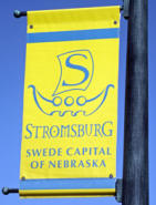
Stromsburg is a small prairie town in Polk County, NE. Stromsburg was settled early in Nebraska history by Swedish settlers. A group of Swedish immigrants coming from the village Strömsborg near the town of Ockelbo, Gästrikland province, Sweden, arrived in the 1860’s after several years in Illinois. This group was led by Lewis Headstrom. The Nebraska town Stromsborg was named after this group’s home village in Sweden. By the 1880’s two brickyards were in operation in the town. Many buildings from ‘native’ brick still stand, including the Viking Center, now a community center. Stromsburg was given the title of the “Swede Capital of Nebraska”. A weekend long Swedish festival is held in June each year and features Stromburg's Swedish heritage. Traditional Swedish foods are prepared and sold.
Kansas
Kansas is located in the Midwestern United States. Residents of Kansas are called "Kansans." The capital of Kansas and the county seat of Shawnee County is Topeka. It is located in northeast Kansas and its population is 127,473 (2010). The largest city and the county seat of Sedgwick County is Wichita with a population of 382,368 (2010). Kansas City is the county seat of Wyandotte County, and the third-largest city of the Kansas City Metropolitan area. Nearly 75 mi (121 km) of the state's northeastern boundary is defined by the Missouri River. In 1803, most of modern Kansas was secured by the United States as part of the Louisiana Purchase. From 1812 to 1821, Kansas was part of the Missouri Territory. In 1827, Fort Leavenworth became the first permanent settlement of white Americans in the future state. The Kansas–Nebraska Act became law on May 30, 1854, establishing the US territories of Nebraska and Kansas, and opening the area to broader settlement. Kansas was admitted to the United States as a slave-free state on January 29, 1861, making it the 34th state to enter the Union. After the Civil War, many veterans constructed homesteads in Kansas. In 1870, the Chisholm Trail was opened and the Wild West-era began in Kansas. The Chisholm Trail was a trail used in the late 19th century to drive cattle overland from ranches in Texas to Kansas railheads, such as Wichita and Dodge City. Wild Bill Hickok (1837 - 1876) was a deputy marshal at Fort Riley and a marshal at Hays and Abilene. Dodge City was another wild cowboy town, and both Bat Masterson (1853 - 1921) and Wyatt Earp (1848 - 1929) worked as lawmen in the town.After the Civil War, the population of Kansas grew rapidly when waves of immigrants turned the prairie into farmland. Today, Kansas is one of the most productive agricultural states, producing high yields of wheat, sorghum, and sunflowers.The western two-thirds of the state, lying in the great central plain of the United States, has a generally flat or undulating surface, while the eastern third has many hills and forests. Kansas covers an area of 82,277 sq mi (213,096 km2). Its width is 417 miles (645 km) and its length is 211 miles (340 km). The highest point is Mount Sunflower at 4,041 ft (1,232 m). The total population is 2,893,957 (2013 est).
Lindsborg
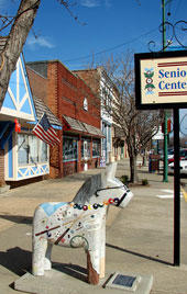
Swedish immigrants also settled in Kansas. Lindsborg is a city in McPherson County and as of the 2010 census, the city population was 3,458. Lindsborg is located 70 miles (110 km) north of Wichita in central Kansas. The city is well-known for its association with Swedish heritage. Lindsborg’s nickname is "Little Sweden" because it was settled by Swedish immigrants in the late 19th century. The City of Lindsborg was settled in the spring of 1869 by a group of Swedish immigrants from Värmland province, Sweden, led by Pastor Olof Olsson. The City of Lindsborg was incorporated in 1879. Today, more than 30 percent of the population is of Swedish heritage. The downtown area features gift shops that specialize in Swedish souvenirs, including various sizes of Dala horses (Dalahäst). The Swedish Pavilion in Lindsborg was originally built as an international exposition building for the 1904 St. Louis World's Fair and later brought to Lindsborg.The city's Swedish name means Linden Castle in English. It was named for 3 men, Lind, Lindgren and Lindahl, who had held prominent positions in a Chicago organization of Swedish farmers (Svenska Lantbrukskompaniet) which was involved in the settling of Lindsborg until 1877.Lindsborg is known for its festival the Svensk Hyllningsfest (Swedish Honoring Festival) and other efforts to remember its Swedish pioneer heritage. Svensk Hyllningsfest is a biennial celebration held in October of odd-numbered years since 1941, to celebrate the town's Swedish heritage. The festival includes arts and crafts, Swedish dancing, Swedish foods including Lutfisk (stockfish), entertainment by local artists and musicians, a parade, and a Swedish smörgåsbord.As of the census of 2000, there were 3,321 people in Lindsborg and 36.0% were of Swedish ancestry. The image to the right shows a Dala horse in Lindsborg, KS. Free image.
California
California, located on the West Coast of the United States, is the most populous state, home to 38,332,521 (2013 est) people, and is the third largest state by area. The four largest cities are Los Angeles, San Diego, San Jose and San Francisco. The state capital is Sacramento in northern California.The region was explored by a number of European expeditions throughout the 16th and 17th centuries. It was claimed by the Spanish Empire as part of Alta California in the larger territory of New Spain. Alta California became a part of Mexico in 1821 after the Mexican War of Independence. In 1846 settlers rebelled against the Mexican rule during the Bear Flag Revolt. Afterwards, rebels raised the Bear Flag (featuring a bear, a star, a red stripe and the words "California Republic") at Sonoma. California was later ceded to the United States in 1848 after the Mexican-American War (1846 – 1848). California was soon organized as the State of California, which was admitted as the 31st state on September 9, 1850.In 1846 the non-native population of California was estimated to be no more than 8,000. After gold was discovered in 1848, the population burgeoned with U.S. citizens, Europeans, Chinese and other immigrants during the great California Gold Rush. By 1854 over 300,000 settlers had come. Between 1847 and 1870, the population of San Francisco increased from 500 to 150,000.By 1920 there were about 32,000 Swedish-born immigrants in California.California covers an area of 163,696 sq mi (423,970 km2) having a width of 250 miles (400 km) and a length of 770 miles (1,240 km). Sweden by comparison covers an area of 173,745 sq mi (449,964 km2) and its largest width is 311 miles (500 km) and its length is 977 miles (1,572 km km). So, both in area and on the map Sweden and California have about the same size and shape.California’s highest point is Mount Whitney at 14,505 ft (4,421.0 m). Much of the state has a Mediterranean climate, with cool, rainy winters and dry summers. Farther inland, one encounters colder winters and hotter summers. Northern parts of the state average higher annual rainfall than the south.Its nickname is The Golden State.The City of Los Angeles, often known by its initials L.A., is the most populous city in the state of California and the second-most populous in the United States, after New York City, with a population at the 2010 United States Census of 3,792,621.
Kingsburg
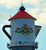
Kingsburg is a city in Fresno County, California, and is located south of Fresno on the banks of the Kings River in central California. The population was 11,382 at the 2010 census.Despite its name this has been a large Swedish community. In the early 1870’s, Swedish immigrants settled in a railroad town called "Kings River Switch". Kingsburg started out as a flag stop on the Central Pacific Railroad called Kings River Switch. In 1874 Kingsburg was called Wheatville and had a post office, later that year the name was changed to Kingsbury. In January 1894 it took on its present spelling, "Kingsburg", which was finally established as a town in 1908. By 1921, 94% of the population within a three-mile radius of Kingsburg was Swedish-American, giving the community the nickname of "Little Sweden". To keep up with the town's Swedish history most retail businesses are designed in Swedish architecture.For much of the town's history the fields around Kingsburg were mostly grape vineyards which produce mainly raisin and table grapes. Kingsburg is the headquarters of Sun-Maid Growers of California, a producer of raisins and other dried fruits.One of the unique landmarks in the community is the Kingsburg water tower, which is shaped like a traditional Swedish coffee pot. The image to the right shows the Kingsburg water tower. The Kingsburg Swedish Festival is the largest and most well-known of Swedish-American festivals drawing people in from all over the country. It is held annually during the third weekend in May. Activities include a Swedish pancake breakfast, a parade and the coronation of the Swedish Festival Queen. As of the 2000 census, 28.6% of Kingsburg's residents were of Swedish descent.
State of New York
The state of New York is located in the Northeastern and Mid-Atlantic regions of the United States. The state is often referred to as New York State to distinguish it from New York City.Albany, with a population of 97,904 (2012), is the state capital and the seat of Albany County. Albany saw its first European settlement in 1614 and was officially chartered as a city in 1686 and became the capital of New York in 1797. The largest city is New York City with a population of 8,405,837 (2013 est). The entire New York Metropolitan Area has a population of 23,508,600 (2010).New York State is bordered by Canada to the north. The western part of the state faces Lake Eire, on whose shores the city of Buffalo (population 261,310) is located at the head of the Niagara River just below Niagara Falls. The Niagara River, in which Niagara Falls is found, runs northward from Buffalo also along New York’s western border into Lake Ontario and serves as part of the International boundary between Canada and the United States. Buffalo is the second most populous city in New York after New York City.The state of New York was one of the 13 original English colonies, which declared their independence from Great Britain and it became the 11th state to ratify the United States Constitution, on July 26, 1788.New York State covers an area of 54,556 sq mi (141,300 km2) having a width of 285 miles (455 km) and a length of 330 miles (530 km). Its highest point is Mount Marcy at 5,344 ft (1,628 m). The population of the state is 19,651,127 (2013 est). Below is a map showing the counties of New York State.
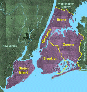
New York City
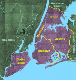
New York City has been the largest port of entry for immigration into the United States since the early 19th century. The Statue of Liberty greeted millions of immigrants as they came to America by ship in the late 19th and early 20th centuries.During the first half of the 19th century immigrants arrived in the harbor area on the Lower East Side of Manhattan, the South Street Seaport. On August 1, 1855, an immigrant station opened at the southernmost tip of Manhattan, Castle Garden. This immigrant station was managed by New York State. However, the need of a larger immigrant station arose after a few decades and on January 1, 1892, a new station was opened, Ellis Island, an island in the Upper New York Bay. Ellis Island was run by the Federal Government. Once passed immigrant processing the long journey began to the final destinations which for most Scandinavians was the Upper Midwest; states such as Minnesota and Illinois. However, not all immigrants left New York City, about 1/3 of the arriving immigrants who passed through Ellis Island stayed in the city.The image to the right shows the 5 New York City Boroughs. The picture is a fee image.New York City traces its roots to its 1624 founding as a trading post by colonists of the Dutch Republic and was named New Amsterdam in 1626. The city and its surroundings came under English control in 1664. The English promptly renamed the city "New York" after the Duke of York. New York grew in importance as a trading port while under British rule in the early 1700’s. It has been the country's largest city since 1790.New York served as the capital of the United States from 1785 until 1790. The Great Irish Famine brought a large influx of Irish immigrants, and by 1860, one in four New Yorkers—over 200,000—had been born in Ireland. Germans comprised another 25% of New York's population by 1860. In 1898, the modern City of New York was formed with the consolidation of Brooklyn (until then a separate city), the County of New York, the County of Richmond, and the western portion of the County of Queens. New York became the most populous urbanized area in the world in early 1920s, overtaking London.The city's nickname is The Big Apple.Boroughs:New York City is composed of five boroughs. Each borough is coextensive with a respective county of New York State. The five boroughs are; Manhattan, Brooklyn, Queens, The Bronx and Staten Island. Brooklyn and Queens make up the western parts of Long Island. The Bronx is the only borough on the main land, the others are on islands. The river on the west side of Manhattan is the Hudson Riverand the river on its east side is the East River.The five counties are; New York County (Manhattan), Bronx County, Kings County (Brooklyn), Queens County and Richmond County (Staten Island).Kennedy Airport (JFK) and LaGuardia Airport (LGA) are located in Queens. Newark Airport (EWR) is located in New Jersey on the westerns side of the state line.Brooklyn:Brooklyn was the New York City Borough that the Swedes who didn’t continue on to other areas of the country were drawn to.Not only were there Swedes in the Scandinavian grouping but Norwegians, Danes and Finns. Today, their bakeries, delicatessens, newspaper and weekly radio programs are all gone from Brooklyn. Brooklyn abounded with “rooming houses”, the early ones, small buildings of 2 or 3 floors where the single immigrant could rent a room and use the common or shared bathroom for all rooms on that floor. Their origin was possibly what was fitting to the small towns and villages. Later, as the immigrants married and became more settled, they were able to move within the same neighborhood or area to somewhat larger quarters and start families. Many clubs were formed during that era that provided social activities for them. A number of these clubs built summer club house in the other Boroughs to “get out into the country” during the hot summers. They too are virtually non-existent today however one such club does still survive in The Bronx on the waterfront – The Mannheim Club.Before Brooklyn was incorporated into New York City in 1898 and before everything became one, it consisted of many small towns and villages – more so than in the other Boroughs. The Bronx was more rural with farms as was Queens. Staten Island was and is even today, somewhat out of the mainstream. However, the Swedes did build a retirement/nursing home on Staten Island, and nearby a cemetery called Valhalla. Manhattan was and is the city center, a place then and now to find employment and for the more affluent, apartments.Naming practice of street names in Manhattan:The naming of roadways in Manhattan is special. Most streets or avenues (roadways) in Manhattan are numbered except for the oldest area at the southern end. All Streets run east and west, all Avenues run north and south – making the City, to some extent, easy to get around in. And although it’s not the geographic center of Manhattan, 5th Avenue is the dividing line between East and West sides of Manhattan island. 5th Avenue runs east of Central Park.All streets east of 5th Avenue have a name with East, for example East 57th Street. In a similar manner, all streets west of 5th Avenue have a name with West, for example West 57th Street. All avenues aren’t numbered but many are. An example of an avenue not being numbered is Park Avenue.
Jamestown
Jamestown is a city in Chautauqua County in the western part of New York State, close to Lake Eire. The population was 31,146 at the 2010 census. The city was founded in 1810 and incorporated as a city in 1827. A great number of Jamestown’s residents were of Swedish descent. According to the 1920 census 18% of the population was born in Sweden and the majority of the population was of Swedish descent. As of the census of 2000, there were 18.1% Swedish descendants in the city. The Swedish influence on the city was immense - it was a village of 2,500 when the first Swedes began arriving in 1849. Like Chicago, Jamestown was literally built by Swedes. By the 1920's the village had changed from a few woolen mills and to hundreds of furniture factories and metal and tool plants, etc. The Swedes not only worked in these factories - most of these companies were owned by Swedes. Jamestown was the home of the Augustana Synod’s Gustavus Adolphus orphanage, and the city had an important furniture industry. The Swedish musical instrument company AB Albin Hagstöm had a branch in Jamestown between 1946 and 1949 which manufactured accordions by the name Hagstrom.
A short description of the States where the majority of Swedish immigrants settled.
States, Counties and Townships
State:The primary political unit of the United States is the State. The 50 individual states and the United States as a whole are each sovereign jurisdictions. In all of the U.S. states, the chief executive is called the Governor. The legislatures of 49 of the 50 states are made up of two chambers: a lower house (termed the House of Representatives, State Assembly or House of Delegates) and a smaller upper house, always termed the Senate. The exception is the unicameral Nebraska Legislature, which is composed of only a single chamber. States can also organize their judicial systems differently from the federal judiciary, as long as they protect the federal constitutional right of their citizens to procedural due process. There are in the United States both federal laws and State laws.Because of the shared sovereignty between each U.S. state and the U.S. federal government, an American is a citizen of both the federal republic and of his or her state of domicile.Kentucky, Massachusetts, Pennsylvania, and Virginia use the official title of Commonwealth rather than State. The term has no legal impact.New England is not a state but a region in the northeastern corner of the United States consisting of the six states of Maine, Massachusetts, New Hampshire, Vermont, Rhode Island, and Connecticut.County:The states are divided into smaller administrative regions, called counties in all but two states, which may be assigned some local governmental authority but are not sovereign. The exceptions are Alaska where the main subdivision is the boroughs and Louisiana which is divided into county-equivalents that are called parishes. County or county-equivalent structure varies widely by state. Counties may contain a number of cities, towns, villages, or sometimes just a part of a city. Some cities are consolidated with, and coterminous with, their counties. Some states contain independent cities that are not part of any county. New York City is coterminous with five counties.A consolidated city-county is a city and county that have been merged into one unified jurisdiction. As such it is simultaneously a city, which is a municipal corporation, and a county, which is an administrative division of a state. It has the powers and responsibilities of both types of entities. An American consolidated city-county corresponds to the Swedish “kommun which is the entity for local administration in Sweden.Township:Towns and townships are subdivisions of counties. However, the powers granted to towns or townships vary considerably from state to state. Some townships have governments and political power, others are simply geographic designations.Towns or townships are used as subdivisions of a county in 20 states, mostly in the Northeast and Midwest.
States where the majority of
Swedish immigrants settled
Below is a short description of the States where the majority of Swedish immigrants settled:
The Emigration from
Sweden to the USA (7e)
Illinois
Illinois is the runner up behind Minnesota in terms of number of Swedish settlers. The Illinois Territory was created on February 3, 1809, with its capital at Kaskaskia, an early French settlement. In 1818, Illinois became the 21st U.S. state. In 1837 the capital was moved to Springfield.The largest city in Illinois is Chicago, the third most populous city in the United States with 2.7 million residents. Chicago was incorporated as a city in 1837 between the Great Lakes and the Mississippi River watershed. Chicago is located at one of few natural harbors in southern Lake Michigan. Though Illinois lies entirely in the Interior Plains, it does have some minor variation in its elevation and its highest point is Charles Mound at 1,235 ft (376 m). Illinois' rich prairie’s major agricultural outputs are corn, soybeans, hogs, cattle, dairy products, and wheat.Because of its nearly 400-mile (644 Km) distance between its northernmost and southernmost extremes, as well as its mid-continental situation, Illinois has a widely varying climate. Most of Illinois has a humid continental climate with hot, humid summers and cold winters. The southernmost part of the state borders on a humid subtropical climate, with more moderate winters. Average yearly precipitation for Illinois varies from just over 48 inches (1,219 mm) at the southern tip to around 35 inches (889 mm) in the northern portion of the state. Normal annual snowfall exceeds 38 inches (965 mm) in the Chicago area. Summer high temperatures averages between 77 and 88 F (25 – 32 C) while winter temperatures are below freezing except for the southernmost parts which have milder winters.Illinois total area is 57,914 sq mi (149,998 km2) and its width is 210 miles (340 km) and its length is 395 miles (629 km). Illinois' rich prairies have attracted great deals of immigrant farmers from Germany and Sweden.
Chicago
Chicago is the third most populous city in the United States, after New York City and Los Angeles with 2.7 million residents. Its metropolitan area, sometimes called Chicagoland, is home to 9.5 million people. The population of Illinois is 12,882,000 (2013 est) with the majority of its residents living in Chicagoland. Chicago is the seat of Cook County in the northeastern corner of Illinois by Lake Michigan.With a population of 350 Chicago was incorporated as a city in 1837. Large parts of the city were destroyed in a fire in 1871. Chicago was the largest “Swedish” city in the United States. In 1900 there were more Swedes living in Chicago than Gothenburg, Sweden and Chicago counted 40 Swedish churches. In 1910 Chicago had about 110,000 Swedish inhabitants. The city’s Swedish heritage can still be seen in the neighborhood of Andersonville in western Edgewater, northern parts of Chicago around North Clark Street and West Foster Avenue. Andersonville was once a little village made up primarily of Swedish immigrants. Today Swedish cultural presence is led by the Swedish American Museum, the Swedish Bakery and other Swedish businesses. Many of Andersonville's Swedes were carpenters, contractors and architects, and played a significant role in building the city. There is a water tower that sits atop the Swedish American Museum in Andersonville painted in the colors of the Swedish flag, yellow cross on a blue background. See image to the left.
Rockford
Rockford, Winnebago County, Illinois, has a large number of Swedish descendants. Between a third and half of the 150,000 residents of Rockford have Swedish roots from places such as Öland, Småland and Blekinge provinces and the city is characterized by its South Swedish heritage. Rockford is a city located on the east and west banks of the Rock River in far northern Illinois and referred to as "The Forest City". Rockford is the county seat of Winnebago County. Rockford was well known for its elm trees, being the reason for its nickname, the Forest City. According to the 2010 U.S. census, the city was home to 152,871 people.Rockford was first settled in 1834–1835 and the settlement was incorporated as a village in 1839, and chartered as a city in 1852. The location got its name Rockford, because of the excellent ford across the Rock River. In 1852 the Galena and Chicago Union Railroad reached the city. By 1860 Rockford had become a significant, growing industrial center.The Swedes primarily settled on the eastern side of the Rock River in Rockford. In 1876, the Rockford Union Furniture Company was established by a group of Swedes led by John Erlander, an immigrant from Småland, Sweden. It was the first of 25 area furniture factories that were formed as cooperatives. By the 1880's the furniture industry was using the talents of Swedish-born craftsmen and financiers, and by the first half of the 20th century Rockford was the second largest furniture manufacturing center in the United States. Still existing today is the Swedish-American Hospital. The hospital is owned and operated by the Swedish American Health System. The hospital was founded in 1911 and opened its doors in 1918.The Erlander Home Museum is the site of the Swedish Historical Society of Rockford. It is located in what was the home of Swedish immigrant John Erlander, former president of the Rockford Union Furniture Company. The Lake-Peterson House, formerly the home of Swede Pehr August Peterson, is listed on the U.S. National Register of Historic Places. Peterson was the founder of the Swedish-American Hospital and a co-founder of the Rockford Union Furniture Company together with John Erlander. The Lake-Peterson House was built in 1873 and is owned and maintained by Swedish American Hospital in Rockford. Peterson bequeathed half a million dollars to a home designed for elderly Swedes in Rockford, the P. A. Peterson Home for the Aged, which was opened in 1941. At Rock Valley College there is Bengt Sjostrom Theater, an outdoor theater.
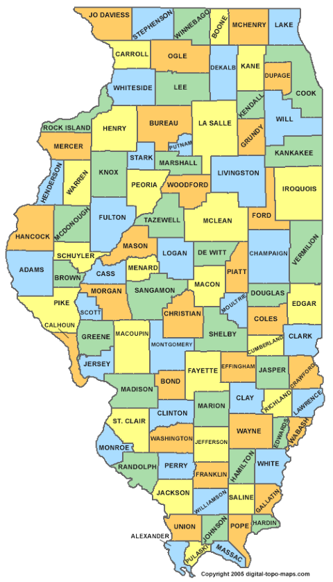
Illinois counties
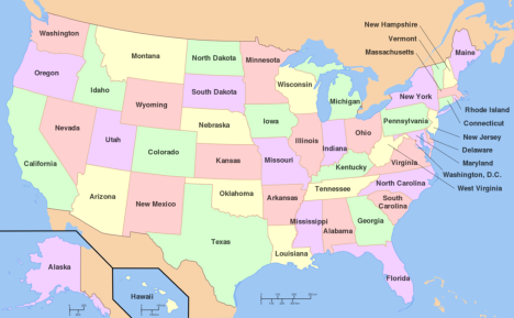
Above, US States.
Minnesota
Minnesota is a state in the Upper Midwest. The largest city in Minnesota is Minneapolis but Saint Paul is the state capital. Saint Paul is adjacent to Minneapolis and they are known collectively as the “Twin Cities”. Minneapolis is located along the banks of the Mississippi River just north of the river’s confluence with the Minnesota River. The population of Minneapolis is 392,880 (2012) and is located in Hennepin County. The population of Saint Paul is 290,770 (2012) and is located in Ramsey County.The portion of the state east of the Mississippi River became part of the United States at the end of the American Revolutionary War (1775 – 1783). Land west of the Mississippi River was acquired with the Louisiana Purchase (1803 – 1804). Minnesota Territory was formed on March 3, 1849. Thousands of people had come to build farms and cut timber, and Minnesota became the 32nd U.S. state on May 11, 1858.Fort Snelling was constructed between 1820 and 1824. It was originally known as Fort Saint Anthony, and was a military fortification located at the confluence of the Minnesota River and the Mississippi River in Hennepin County, Minnesota. The first permanent settlements arose at that time.The railroad between Chicago and Minneapolis was opened in 1867 which made it easier for immigrants to arrive in Minnesota. The state of Minnesota is the state where most Swedish immigrants settled having a large share of Swedes and other Scandinavians. Minnesota's nickname is The Land of 10,000 Lakessince there are many lakes in the state. The highest point is Eagle Mountain at 2,302 ft (701 m). There are several mountain chains west of Lake Superior stretching in a southwestern direction. West and south of this region are extended areas of prairie with fertile loess. Minnesota is divided into 87 counties. The population of Minnesota is 5,420,380 (2013 est.).Together with Minnesota the states North Dakota, South Dakota and Wisconsin makes up the region Upper Midwest which is a part of the Midwest. The area of Minnesota is 86,939 sq. mi (225,181 km2) which constitutes 2.25% of the United States’ total area. As a comparison the largest province in Sweden, Lappland, covers an area of 42,356 sq mi (109,702 km2).Minnesota’s width is 200–350 miles (320–560 km) and its length is 400 miles (640 km).Minnesota faces the Canadian border to the north and Lake Superior in the northeast. The climate of Minnesota is continental with large differences in temperature between summer and winter. The average January temperature is 11.3 F (-11.5 C) which makes it the coldest month of the year. The warmest month is July with an average temperature of 73 F (23 C). The average annual precipitation is 28 in (719 mm).
Chisago County, MN
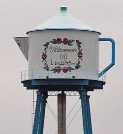
Chisago County is a county in Central East Minnesota about 35 miles (55 km) north-east of Saint Paul and faces Wisconsin on its eastern side. As of the 2010 census, the population was 53,887. Its county seat is Center City which has a population of 500. The major cities are Lindstrom with a population of 4,500 (2010) and Chisago City with about 5,000 residents (2010).Chisago County is like many other counties in Minnesota strongly influenced by Swedish immigrants and a county where an overwhelmingly amount of Swedish immigrants settled during the second half of the 1800’s. It was here where Vilhelm Moberg did his research for his The Emigrants suite in the 1950's.Chisago City: Chisago City is located between the twin lakes of Chisago Lake and Green Lake, and is part of the Chisago lakes region. The city was founded by Swedish immigrants in the 1850's. It was originally settled one mile south, but when the railroad bypassed the town in 1880, the city moved closer to the railroad, as often happened during that time.The city is located approximately 35 miles (55 km) northeast of downtown Minneapolis–Saint Paul. Vilhelm Moberg Park features the bronze statue of Vilhelm Moberg holding his bicycle for which it was named. The population was 4,967 at the 2010 census.Lindstrom:Another city in Chisago County that bears a Swedish heritage is Lindstrom. The city was founded in 1853 by Daniel Lindström from Hassela, Hälsingland province, Sweden. You see the city name spelled Lindstrom as well as Lindström. The city of Lindström was incorporated in 1894, 41 years later. Lindström was settled predominantly by Swedish immigrants and their families. The inhabitants today are largely decedents to Swedish immigrants and some elderly still speaks Swedish. Many stores in Lindstrom have Swedish names and Swedish flags hang outside the stores. Lindström's motto is America's Little Sweden. The image to the right shows Lindström's old water tower which has the shape of a typical Swedish coffee pot, a community landmark. The text on the tower is in Swedish and reads "Välkommen till Lindström" (Welcome to Lindström). The photo is a free image.The Swedish author Vilhelm Moberg visited the area in the late 1940’s to gather material for his emigrant epos, The Emigrant series. The novels are primarily about the fictitious farmer Karl-Oskar Nilsson and his wife Kristina from Ljuder parish, Småland. The fictitious family settled by Lake Ki-Chi-Saga in the novels. The name of the lake is today Lake Chisago. Lindström celebrates Karl Oskar and Kristina annually with Karl Oskar Days. This event takes place mid-July and includes such activities as the coronation of a "Karl Oskar Princess", parades, a street dance, and fireworks. There are statues of Karl Oskar and Kristina in Lindström, as a tribute to the early Swedish immigrants whose descendants continue to populate the area. Since 1990, anyone who has taken U.S. Highway 8 from north of Forest Lake to Lindström has driven on the Moberg Trail. As of the census of 2000 there were 3,015 people residing in the city. About 22.8% of the population was Swedish descendants. Lindström is located about 35 miles (55 km) north-east of Minneapolis–Saint Paul.
Mora, Kanabec County
The city of Mora in Kanabec County in central Minnesota (just north of Chicago County) is another city which is influenced by its Swedish heritage. The city is the county seat and its population was 3,571 at the 2010 census.Mora received its name in 1882 from Israel Israelson (Israelsson) who together with his family had emigrated from Sweden in 1871. The name was suggested by Israelson for his home town Mora, Dalarna province, Sweden. It was first surveyed and mapped out (platted) on May 19, 1882, incorporated as a village in March 1891, and was designated a city by state statute in 1973. Mora is located 72 miles (115 Km) north of Minneapolis and St. Paul. Mora's sister city and namesake is Mora, Sweden. The image to the left shows the gigantic Dala horse in Mora, Minnesota. Notice the blue and yellow Swedish flag flying in the background. The photo is a free image.There is a gigantic Dala horse in Mora, MN, and a Mora clockcommemorating the town's Swedish roots. The city of Mora also plays host each February to the Mora Vasaloppet, the largest cross-country ski race in Minnesota, the Mora Half-Marathon, and the Mora Bicycle Tour. The Vasaloppet (The Vasa race) in Sweden is an annual long distance 90 km (56 mi) cross-country ski race (ski marathon) between the village of Sälen and town of Mora held on the first Sunday in March and has about 15,000 racers. The race has a mass start, i.e. all competitors start at the same time. The race was first run in 1922, inspired by a run by King Gustav Vasa of Sweden in 1520. It is the oldest, the longest, and the biggest (in terms of participants) cross-country ski race in the world.
In colonial times, Iowa was a part of French Louisiana. After the 1803 Louisiana Purchase, Iowa was placed under United States control. The first American settlers officially moved to Iowa in June 1833. On July 4, 1838, the U.S. Congress established the Territory of Iowa. On December 28, 1846, Iowa became the 29th state in the Union.Iowa occupies an area of 56,272 sq mi (145,743 km2), its width is 310 miles (500 km) and its length is 199 miles (320 km). The population of Iowa is 3,090,416 (2013 est).The Highest point is Hawkeye Point at 1,671 ft (509 m). There are several natural lakes in the state.Iowa’s capital and largest city is Des Moines, Polk County. The city's population was 203,433 as of the 2010 census. It was founded in 1843 and incorporated on September 22, 1851, as Fort Des Moines which was shortened to "Des Moines" in 1857.Iowa's natural vegetation is tallgrass prairie and savanna in upland areas. Most of Iowa is used for agriculture; crops cover 60% of the state. The introduction of railroads in the 1850s and 1860s transformed Iowa into a major agricultural producer in the heart of the Corn Belt. Iowa's main agricultural outputs are hogs, corn, soybeans, oats, cattle, eggs, and dairy products.Many Swedish immigrants settled in the northeastern parts of Iowa.
Wisconsin
Wisconsin was first in the hands of the French but they made no permanent settlements in the area before Great Britain won control of the region following the French and Indian War in 1763. Wisconsin became a territorial possession of the United States in 1783 after the American Revolutionary War. However, the British remained in control until after the War of 1812 which finally established an American presence in the area. Wisconsin Territory was organized in 1836. Continued settlement led to statehood on May 29, 1848 (30th State).Wisconsin is located in the north-central United States, in the Midwest and Great Lakes regions. It is bordered by Lake Michigan to the east and Lake Superior to the north. Madison, Dane County, is the State capital but Milwaukee is the largest city. As of 2012, Madison had an estimated population of 240,323. According to 2010 census data, the City of Milwaukee has a population of 594,833.Wisconsin occupies an area of 65,497.82 sq mi (169,639 km2), its width is 260 miles (420 km) and its length is 310 miles (500 km). The population of Wisconsin is 5,726,398 (2012 est). The Highest point is Timms Hill at 1,951 ft (595 m).Wisconsin is known as "America's Dairyland" because it is one of the nation's leading dairy producers. Lumbering had deforested most of the state.
Michigan
Michigan is located in the Great Lakes region of the United States. The state consists of two peninsulas, the Lower Peninsula and the Upper Peninsula. The two peninsulas are separated from each other by the Straits of Mackinac, a five-mile (8 km) channel but are connected by the Mackinac Bridge. Michigan is bounded by four of the five Great Lakes, plus Lake Saint Clair. Michigan also has a great number of inland lakes and ponds. The heavily forested Upper Peninsula is relatively mountainous in the west.Michigan was first colonized by French explorers. After the defeat of France in the French and Indian War in 1762 the region came under British rule. After the American Revolutionary War it was ceded to the United States. In 1805, the Michigan Territory was formed, which lasted until it was admitted into the Union on January 26, 1837, as the 26th state. The state's highest point, in the Huron Mountains northwest of Marquette, is Mount Arvon at 1,979 feet (603 m). The highest point in the Lower Peninsula is Briar Hill at 1,705 feet (520 m). The Lower Peninsula is often noted to be shaped like a mitten. The Upper Peninsula is influenced by the numerous Scandinavian (especially Finns) and Canadian immigrants who settled the area during the lumbering and mining boom of the late 19th century.The state capital is Lansing but the largest city is Detroit (population 2013: 681,090). Michigan covers an area of 96,716 sq mi (250,493 km2). The population of Michigan is 9,895,622 (2013 est). The state is widely known as the center of the U.S. automotive industry, being home to the country’s three major automobile companies.
Nebraska
Nebraska is located on the Great Plains of the Midwestern United States.Its state capital is Lincoln but its largest city is Omaha (population 408,958 (2010)), which is on the Missouri River. The state is crossed by many historic trails such as California Trial and Oregon Trial, but it was the California Gold Rush 1848 that first brought large numbers of non-indigenous settlers to the area. On May 30, 1854, the US Congress created the Nebraska territory. The territorial capital of Nebraska was Omaha. Nebraska became the 37th state on March 1, 1867, and the capital was moved from Omaha to the center at Lancaster, later renamed Lincoln after President Abraham Lincoln. Nebraska covers an area of 77,354 sq mi (200,520 km2) and its width is 210 miles (340 km) and its length is 430 miles (690 km). The total population is 1,868,516 (2013 est). Its highest point is Panorama Point at 5,424 ft (1,654 m).During the 1870’s to the 1880’s, Nebraska experienced a large growth in population. Because so few trees grew on the prairies, many of the first farming settlers built their homes of sod.There are wide variations between winter and summer temperatures, and violent thunderstorms and tornadoes are common. The state is characterized by treeless prairie.In Omaha there was an early population of Danes and Swedes. Omaha boasted an area of the city with such a heavy concentration of Swedes that it was called "Little Stockholm". That early area was in the Near North Side neighborhood. Further north in the Kountze Place neighborhood was another area with "many Swedes, some of the 'better class'". Other professional people who were from Sweden lived in the Gifford Park neighborhood. By 1930, Swedes made up more than 10 percent of Omaha's population. In 1871, a committee of Swedes came from Illinois to determine whether the Nebraska prairie was suitable for Swedish settlement and farming. When they did it led to a variety of towns of Swedish influence being settled, including Stromsburg, Oakland, Pender, Wakefield, and Wausa (Knox County). Other significant Swedish populations in Nebraska included Mead, Malmo (Saunders County), and Swedeburg. It also led to the development of Omaha's substantial Swedish population.
Stromsburg
Stromsburg is a small prairie town in Polk County, NE. Stromsburg was settled early in Nebraska history by Swedish settlers. A group of Swedish immigrants coming from the village Strömsborg near the town of Ockelbo, Gästrikland province, Sweden, arrived in the 1860’s after several years in Illinois. This group was led by Lewis Headstrom. The Nebraska town Stromsborg was named after this group’s home village in Sweden. By the 1880’s two brickyards were in operation in the town. Many buildings from ‘native’ brick still stand, including the Viking Center, now a community center. Stromsburg was given the title of the “Swede Capital of Nebraska”. A weekend long Swedish festival is held in June each year and features Stromburg's Swedish heritage. Traditional Swedish foods are prepared and sold.
Kansas
Kansas is located in the Midwestern United States. Residents of Kansas are called "Kansans." The capital of Kansas and the county seat of Shawnee County is Topeka. It is located in northeast Kansas and its population is 127,473 (2010). The largest city and the county seat of Sedgwick County is Wichita with a population of 382,368 (2010). Kansas City is the county seat of Wyandotte County, and the third-largest city of the Kansas City Metropolitan area. Nearly 75 mi (121 km) of the state's northeastern boundary is defined by the Missouri River. In 1803, most of modern Kansas was secured by the United States as part of the Louisiana Purchase. From 1812 to 1821, Kansas was part of the Missouri Territory. In 1827, Fort Leavenworth became the first permanent settlement of white Americans in the future state. The Kansas–Nebraska Act became law on May 30, 1854, establishing the US territories of Nebraska and Kansas, and opening the area to broader settlement. Kansas was admitted to the United States as a slave-free state on January 29, 1861, making it the 34th state to enter the Union. After the Civil War, many veterans constructed homesteads in Kansas. In 1870, the Chisholm Trail was opened and the Wild West-era began in Kansas. The Chisholm Trail was a trail used in the late 19th century to drive cattle overland from ranches in Texas to Kansas railheads, such as Wichita and Dodge City. Wild Bill Hickok (1837 - 1876) was a deputy marshal at Fort Riley and a marshal at Hays and Abilene. Dodge City was another wild cowboy town, and both Bat Masterson (1853 - 1921) and Wyatt Earp (1848 - 1929) worked as lawmen in the town.After the Civil War, the population of Kansas grew rapidly when waves of immigrants turned the prairie into farmland. Today, Kansas is one of the most productive agricultural states, producing high yields of wheat, sorghum, and sunflowers.The western two-thirds of the state, lying in the great central plain of the United States, has a generally flat or undulating surface, while the eastern third has many hills and forests. Kansas covers an area of 82,277 sq mi (213,096 km2). Its width is 417 miles (645 km) and its length is 211 miles (340 km). The highest point is Mount Sunflower at 4,041 ft (1,232 m). The total population is 2,893,957 (2013 est).
Lindsborg
Swedish immigrants also settled in Kansas. Lindsborg is a city in McPherson County and as of the 2010 census, the city population was 3,458. Lindsborg is located 70 miles (110 km) north of Wichita in central Kansas. The city is well-known for its association with Swedish heritage. Lindsborg’s nickname is "Little Sweden" because it was settled by Swedish immigrants in the late 19th century. The City of Lindsborg was settled in the spring of 1869 by a group of Swedish immigrants from Värmland province, Sweden, led by Pastor Olof Olsson. The City of Lindsborg was incorporated in 1879. Today, more than 30 percent of the population is of Swedish heritage. The downtown area features gift shops that specialize in Swedish souvenirs, including various sizes of Dala horses (Dalahäst). The Swedish Pavilionin Lindsborg was originally built as an international exposition building for the 1904 St. Louis World's Fair and later brought to Lindsborg.The city's Swedish name means Linden Castle in English. It was named for 3 men, Lind, Lindgren and Lindahl, who had held prominent positions in a Chicago organization of Swedish farmers (Svenska Lantbrukskompaniet) which was involved in the settling of Lindsborg until 1877.Lindsborg is known for its festival the Svensk Hyllningsfest (Swedish Honoring Festival) and other efforts to remember its Swedish pioneer heritage. Svensk Hyllningsfest is a biennial celebration held in October of odd-numbered years since 1941, to celebrate the town's Swedish heritage. The festival includes arts and crafts, Swedish dancing, Swedish foods including Lutfisk (stockfish), entertainment by local artists and musicians, a parade, and a Swedish smörgåsbord.As of the census of 2000, there were 3,321 people in Lindsborg and 36.0% were of Swedish ancestry. The image to the right shows a Dala horse in Lindsborg, KS. Free image.
California
California, located on the West Coast of the United States, is the most populous state, home to 38,332,521 (2013 est) people, and is the third largest state by area. The four largest cities are Los Angeles, San Diego, San Jose and San Francisco. The state capital is Sacramento in northern California.The region was explored by a number of European expeditions throughout the 16th and 17th centuries. It was claimed by the Spanish Empire as part of Alta California in the larger territory of New Spain. Alta California became a part of Mexico in 1821 after the Mexican War of Independence. In 1846 settlers rebelled against the Mexican rule during the Bear Flag Revolt. Afterwards, rebels raised the Bear Flag (featuring a bear, a star, a red stripe and the words "California Republic") at Sonoma. California was later ceded to the United States in 1848 after the Mexican-American War (1846 – 1848). California was soon organized as the State of California, which was admitted as the 31st state on September 9, 1850.In 1846 the non-native population of California was estimated to be no more than 8,000. After gold was discovered in 1848, the population burgeoned with U.S. citizens, Europeans, Chinese and other immigrants during the great California Gold Rush. By 1854 over 300,000 settlers had come. Between 1847 and 1870, the population of San Francisco increased from 500 to 150,000.By 1920 there were about 32,000 Swedish-born immigrants in California.California covers an area of 163,696 sq mi (423,970 km2) having a width of 250 miles (400 km) and a length of 770 miles (1,240 km). Sweden by comparison covers an area of 173,745 sq mi (449,964 km2) and its largest width is 311 miles (500 km) and its length is 977 miles (1,572 km km). So, both in area and on the map Sweden and California have about the same size and shape.California’s highest point is Mount Whitney at 14,505 ft (4,421.0 m). Much of the state has a Mediterranean climate, with cool, rainy winters and dry summers. Farther inland, one encounters colder winters and hotter summers. Northern parts of the state average higher annual rainfall than the south.Its nickname is The Golden State.The City of Los Angeles, often known by its initials L.A., is the most populous city in the state of California and the second-most populous in the United States, after New York City, with a population at the 2010 United States Census of 3,792,621.
Kingsburg
Kingsburg is a city in Fresno County, California, and is located south of Fresno on the banks of the Kings River in central California. The population was 11,382 at the 2010 census.Despite its name this has been a large Swedish community. In the early 1870’s, Swedish immigrants settled in a railroad town called "Kings River Switch". Kingsburg started out as a flag stop on the Central Pacific Railroad called Kings River Switch. In 1874 Kingsburg was called Wheatville and had a post office, later that year the name was changed to Kingsbury. In January 1894 it took on its present spelling, "Kingsburg", which was finally established as a town in 1908. By 1921, 94% of the population within a three-mile radius of Kingsburg was Swedish-American, giving the community the nickname of "Little Sweden". To keep up with the town's Swedish history most retail businesses are designed in Swedish architecture.For much of the town's history the fields around Kingsburg were mostly grape vineyards which produce mainly raisin and table grapes. Kingsburg is the headquarters of Sun-Maid Growers of California, a producer of raisins and other dried fruits.One of the unique landmarks in the community is the Kingsburg water tower, which is shaped like a traditional Swedish coffee pot. The image to the right shows the Kingsburg water tower. The Kingsburg Swedish Festival is the largest and most well-known of Swedish-American festivals drawing people in from all over the country. It is held annually during the third weekend in May. Activities include a Swedish pancake breakfast, a parade and the coronation of the Swedish Festival Queen. As of the 2000 census, 28.6% of Kingsburg's residents were of Swedish descent.
State of New York
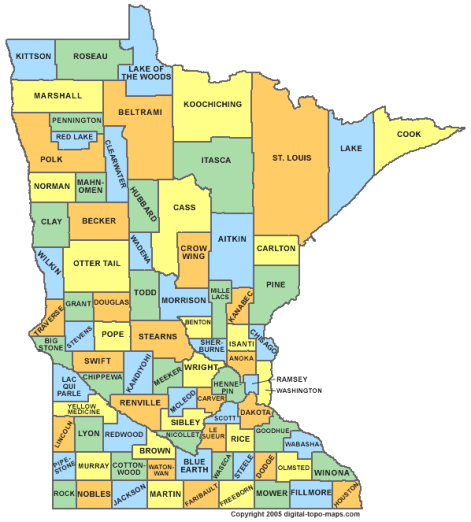
The state of New York is located in the Northeastern and Mid-Atlantic regions of the United States. The state is often referred to as New York State to distinguish it from New York City.Albany, with a population of 97,904 (2012), is the state capital and the seat of Albany County. Albany saw its first European settlement in 1614 and was officially chartered as a city in 1686 and became the capital of New York in 1797. The largest city is New York City with a population of 8,405,837 (2013 est). The entire New York Metropolitan Area has a population of 23,508,600 (2010).New York State is bordered by Canada to the north. The western part of the state faces Lake Eire, on whose shores the city of Buffalo (population 261,310) is located at the head of the Niagara River just below Niagara Falls. The Niagara River, in which Niagara Falls is found, runs northward from Buffalo also along New York’s western border into Lake Ontario and serves as part of the International boundary between Canada and the United States. Buffalo is the second most populous city in New York after New York City.The state of New York was one of the 13 original English colonies, which declared their independence from Great Britain and it became the 11th state to ratify the United States Constitution, on July 26, 1788.New York State covers an area of 54,556 sq mi (141,300 km2) having a width of 285 miles (455 km) and a length of 330 miles (530 km). Its highest point is Mount Marcy at 5,344 ft (1,628 m). The population of the state is 19,651,127 (2013 est). Below is a map showing the counties of New York State.
New York City
New York City has been the largest port of entry for immigration into the United States since the early 19th century. The Statue of Liberty greeted millions of immigrants as they came to America by ship in the late 19th and early 20th centuries.During the first half of the 19th century immigrants arrived in the harbor area on the Lower East Side of Manhattan, the South Street Seaport. On August 1, 1855, an immigrant station opened at the southernmost tip of Manhattan, Castle Garden. This immigrant station was managed by New York State. However, the need of a larger immigrant station arose after a few decades and on January 1, 1892, a new station was opened, Ellis Island, an island in the Upper New York Bay. Ellis Island was run by the Federal Government. Once passed immigrant processing the long journey began to the final destinations which for most Scandinavians was the Upper Midwest; states such as Minnesota and Illinois. However, not all immigrants left New York City, about 1/3 of the arriving immigrants who passed through Ellis Island stayed in the city.The image to the right shows the 5 New York City Boroughs. The picture is a fee image.New York City traces its roots to its 1624 founding as a trading post by colonists of the Dutch Republic and was named New Amsterdam in 1626. The city and its surroundings came under English control in 1664. The English promptly renamed the city "New York" after the Duke of York. New York grew in importance as a trading port while under British rule in the early 1700’s. It has been the country's largest city since 1790.New York served as the capital of the United States from 1785 until 1790. The Great Irish Famine brought a large influx of Irish immigrants, and by 1860, one in four New Yorkers—over 200,000—had been born in Ireland. Germans comprised another 25% of New York's population by 1860. In 1898, the modern City of New York was formed with the consolidation of Brooklyn (until then a separate city), the County of New York, the County of Richmond, and the western portion of the County of Queens. New York became the most populous urbanized area in the world in early 1920s, overtaking London.The city's nickname is The Big Apple.Boroughs:New York City is composed of five boroughs. Each borough is coextensive with a respective county of New York State. The five boroughs are; Manhattan, Brooklyn, Queens, The Bronx and Staten Island. Brooklyn and Queens make up the western parts of Long Island. The Bronx is the only borough on the main land, the others are on islands. The river on the west side of Manhattan is the Hudson Riverand the river on its east side is the East River.The five counties are; New York County (Manhattan), Bronx County, Kings County (Brooklyn), Queens County and Richmond County (Staten Island).Kennedy Airport (JFK) and LaGuardia Airport (LGA) are located in Queens. Newark Airport (EWR) is located in New Jersey on the westerns side of the state line.Brooklyn:Brooklyn was the New York City Borough that the Swedes who didn’t continue on to other areas of the country were drawn to.Not only were there Swedes in the Scandinavian grouping but Norwegians, Danes and Finns. Today, their bakeries, delicatessens, newspaper and weekly radio programs are all gone from Brooklyn. Brooklyn abounded with “rooming houses”, the early ones, small buildings of 2 or 3 floors where the single immigrant could rent a room and use the common or shared bathroom for all rooms on that floor. Their origin was possibly what was fitting to the small towns and villages. Later, as the immigrants married and became more settled, they were able to move within the same neighborhood or area to somewhat larger quarters and start families. Many clubs were formed during that era that provided social activities for them. A number of these clubs built summer club house in the other Boroughs to “get out into the country” during the hot summers. They too are virtually non-existent today however one such club does still survive in The Bronx on the waterfront – The Mannheim Club.Before Brooklyn was incorporated into New York City in 1898 and before everything became one, it consisted of many small towns and villages – more so than in the other Boroughs. The Bronx was more rural with farms as was Queens. Staten Island was and is even today, somewhat out of the mainstream. However, the Swedes did build a retirement/nursing home on Staten Island, and nearby a cemetery called Valhalla. Manhattan was and is the city center, a place then and now to find employment and for the more affluent, apartments.Naming practice of street names in Manhattan:The naming of roadways in Manhattan is special. Most streets or avenues (roadways) in Manhattan are numbered except for the oldest area at the southern end. All Streets run east and west, all Avenues run north and south – making the City, to some extent, easy to get around in. And although it’s not the geographic center of Manhattan, 5th Avenue is the dividing line between East and West sides of Manhattan island. 5th Avenue runs east of Central Park.All streets east of 5th Avenue have a name with East, for example East 57th Street. In a similar manner, all streets west of 5th Avenue have a name with West, for example West 57th Street. All avenues aren’t numbered but many are. An example of an avenue not being numbered is Park Avenue.
Jamestown
Jamestown is a city in Chautauqua County in the western part of New York State, close to Lake Eire. The population was 31,146 at the 2010 census. The city was founded in 1810 and incorporated as a city in 1827. A great number of Jamestown’s residents were of Swedish descent. According to the 1920 census 18% of the population was born in Sweden and the majority of the population was of Swedish descent. As of the census of 2000, there were 18.1% Swedish descendants in the city. The Swedish influence on the city was immense - it was a village of 2,500 when the first Swedes began arriving in 1849. Like Chicago, Jamestown was literally built by Swedes. By the 1920's the village had changed from a few woolen mills and to hundreds of furniture factories and metal and tool plants, etc. The Swedes not only worked in these factories - most of these companies were owned by Swedes. Jamestown was the home of the Augustana Synod’s Gustavus Adolphus orphanage, and the city had an important furniture industry. The Swedish musical instrument company AB Albin Hagstöm had a branch in Jamestown between 1946 and 1949 which manufactured accordions by the name Hagstrom.