
Copyright © Hans Högman 2021-07-24


Introduction
Before the modern land reforms were implemented
in Sweden, the land in the villages was divided into
different ownership systems. The common feature
of these systems was that the different farms'
properties were strongly intermingled with each
other. Preparing the land, sowing, harvesting, and
putting animals out to pasture after harvest needed
to be coordinated.
The vast majority of farmers in Sweden lived in
villages from the Middle Ages onwards and
cultivated strips of tilled land (tegar). The farmers'
strips of land were narrow and located next to each
other in the fields. The system meant that each
farmer had shares of all different types of land in the
village. But the “teg” system with strips of tilled land
required that the land was cultivated in a
coordinated way in the village, or even that sowing
and harvesting took place together with the other
farmers in the village. It was also at places so far
from the village to the outermost strips of land that
they were difficult to cultivate.
During the 18th century, thoughts and ideas about
various land reforms began to spread in Sweden.
Inspiration was drawn from England, Germany, and
Denmark, where similar reforms had already been
implemented with successful results. The basic idea
of the land reforms was to make farming more
efficient by limiting the number of fields and
meadows per farm and instead grouping the
individual farm units' properties into larger
undivided parcels.
The land reforms, mainly the "Enskifte" in Skåne and
the "Laga skifte" in the rest of the country, were of
great importance for the future development of
agriculture and resulted in increased cultivation and
grain production.
Land Reform
Land reform is a purposive change in the way in
which agricultural land is held or owned, the
methods of cultivation that are employed, or the
relation of agriculture to the rest of the economy.
Land reform may consist of a government-initiated
or government-backed land redistribution, generally
of agricultural land, or initiated by interested groups.
Land reform has become synonymous with agrarian
reform or a rapid improvement of the agrarian
structure. It also deals with the state of technology.
The Swedish land reforms didn’t aim to transfer land
ownership away from owners, but merely redistribute
the farmers’ various strips of agricultural land in a
village into larger undivided parcels per farmer.
The Swedish term for land reform is
“Skiftesreform”.
Rural Agricultural Villages
Village (Swe: By) may denote a named place
consisting of at least two neighbouring farms and
possibly several crofts in the countryside, but was
also a legal designation for a collection of farms that
are or have been a community for the common
ownership and use of certain land or forest - so-called
commons (farming villages). This latter definition
applied before the land reform of the early
nineteenth century to Swedish and Finnish land
parcels shared by several farms. The term is used
primarily for agricultural villages. In a terraced
village (Swe: radby), the farms are arranged in a row,
usually along the village street. With the land reform
of the 19th century, most of the row villages
disappeared.
The image to
the right shows
a view from a
terraced village
(Swe: radby) in
Eriksöre, Kalmar
County, in 1900.
Image: Kalmar
Läns Museum.
ID: KLMF.A01558.
In the agricultural villages, the land was arranged
in parcels called "tegskifte". This meant that the
different landowners of the village (Swe: byamän)
were clearly defined, as well as the share each of
them had in the village.
Based on this key, the village plot of land (where the
farm buildings were located) was divided into legal
shares, as were the cultivated fields. The meadow
(where the hay was harvested) and the pasture were
common (shared between the farmers in the village),
but the sharing key defined how much of the hay
would go to each person and how much livestock
each person could have on the pasture.
This is called “tegskifte” in Swedish and the strips of
tilled land established by the distribution of
farmland are called ”tegar” (plural).
People who were not joint owners of the village had
to pay to build houses on the village land or use the
pasture.
In the 1734 law, the first chapter of the “Bygninga
Balken” (Village Section) defined "How the plot of land
for a village shall be laid out, and farmland
distributed". The law stipulated that every part of the
village area was to be divided among all the co-
owners (Swe: Byamännen). Furthermore, the
individual farmsteads’ strips of tilled land (Swe:
tegar) were to be laid out in the relation to each
other in the same way as the farms were adjacent to
each other in the village.
Village Council
It was usually the village council (bystämman) that
administered and managed the strips of tilled land.
The village council was headed by a village elder
(Byålderman) appointed by the “byamännen” (the
landed people in the village) to manage the village's
farm activities, and the village rules were written
down in a Village Ordinance (Byordning). The
members of the council are called the “Byalaget”
(Village Councilors) or “Byarådet”.
The members of the village council are those who
own land in the village (more than just a plot) and
were, therefore the owners of agricultural property.
The village council governed the village according to
customary law, often codified in a specially written
village ordinance (byordning), a statute on common
affairs laid down by the district court of law. The
village elder is elected by merit or in order according
to a rotation system. The most important meeting of
the year is usually held around Walpurgis Eve and is
called the May Meeting.
The image to the right shows village councillors of
Kila village, Hycklinge parish, Östergötland County, at
a village council meeting. Photo: Sigurd Erixon.
Image: Wikipedia.
A village ordinance (byordning) mainly contained
rules on livestock and fencing (of central importance
before the Laga Skifte land reform change in the 19th
century). The use of the common property (mills,
sandpits, peat quarries, fishing waters) was also
regulated in the village ordinances, as were often fire
protection, poor relief issues, the relationship
between the propertied and non-propertied
villagers, and even certain moral issues. The village
council could levy fines for breaches of the village
ordinance. Sometimes the village dealt with matters
that were usually within the jurisdiction of the parish
council.
The villages were often also inhabited by crofters,
tenants, and others who lived on houses that stand
on other’s freehold ground. These people were not
involved in decisions concerning the mutual affairs
of the village and did not have the right to vote at
the village council meeting.
To achieve greater uniformity in the village councils'
ordinances, the government issued an Act called
“Mönsterbyordning” (Model Village Ordinance) in
1742.
The construction and maintenance of fences (Swe:
gärdsgård) was important and carefully prescribed by
law. The fences were there to prevent the livestock
or wild animals from entering the fields and
destroying the crops. All fields were therefore
fenced. Each homestead in the village was assigned
a section of the fenced farmland for which it was
responsible, and the fences were usually inspected
twice a year. There were also fences around the
pastures to prevent animals from escaping or
entering the cultivation fields. Both at the cultivation
fields and the pastures there were gates in the
fences and everyone who passed a gate needed to
close it behind them. It was not uncommon for a
public road to run through the pasture and thus
wayfarers had to pass many gates to be opened and
closed.
When it was time to sow or harvest, this had to be
done at the same time on all strips of tilled land, as
many farmer's strips could not be accessed without
first passing through others. This meant that every
farm in the village had to have the soil prepared in
time for everyone to sow on the day set by the
village council. This also applied to harvesting, of
course. Similar rules applied to the hay-making of
meadows. Furthermore, the hay had to be put in by
a certain day, after which the cattle were usually let
out to graze on the meadows.
History of Agriculture
Agriculture originated 12,000 years ago in several
independent locations.
Different crops were exploited in each location,
which meant that the trade networks that later
emerged could spread developed crops to new
markets. In the Middle East and Europe, wheat
became the most important crop, in Asia rice and
millet were grown, and in America maize, cassava,
beans, and potatoes. Agriculture produced a surplus
that both increased the population and gave rise to
the first city-states.
Around 10,000 years BC, people lived as hunters and
gatherers. The transformation of people's lives
brought about by agriculture had revolutionary
consequences and is often referred to as the
Neolithic Revolution. Agriculture meant an increased
availability of food, which in turn meant rapid
population growth and larger permanent
settlements. These settlements developed into the
first city-states.
Because agriculture produced a surplus, this surplus
could be exchanged for other goods. Surplus and
trade meant that some groups of people could earn
a living in ways other than farming, such as crafts.
Surpluses were also used to pay for common goods:
defenses, churches, irrigation. While this led to
increased specialization, it also led to increased
stratification.
Agriculture came to Sweden from the continent
around 4,000 years BC. It seems to have been a
rapid process (not measurable with the 14C
method). It seems that indigenous Mesolithic groups
take up the so-called funnel beam culture. This was
the first farming culture in the Nordic countries.
During the European Middle Ages, there were many
advances in agriculture.
In the 700s, the introduction of the bow wood from
Asia made it possible to use horses to pull heavy
loads. The horses could be used to plow the land;
previously oxen had been used for this as the horses
were strangled by the harness. The wheeled plow
was an even more important invention, especially in
heavy soil.
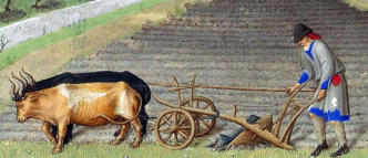
The image to the
right shows a
farmer with a
wheeled plow.
Image: Wikipedia.
In much of Europe, the three-year rotation (three-
field system) was introduced, which meant that
each field was cultivated one year with spring grain
(such as oats), one year with winter grain, and left
fallow only every third year. During the fallow period,
the land was fertilized by livestock. This increased
production and since there were two harvests, there
was less risk of crop failure. Up until the 1300s, the
grain rate (the ratio of the harvest to seed) rose
sharply. The next major increase would not occur
until the 18th century, because in the early modern
period there were no major changes in agriculture
except for the growth of farming units and a more
market-oriented approach to production.
The Agrarian Revolution
The Agrarian Revolution is an agricultural
revolution that is said to have taken place in the late
18th century in Western Europe, particularly in
England and France. It later spread to other
countries. In Sweden, it corresponded to several
successive land reforms in the late 18th and early
19th centuries. Agrarian comes from the Latin word
for the field, ager.
Towards the end of the 18th century, major changes
took place in agriculture. For a long time, farmers
had been cultivating several but small tilled strips of
land. These small strips were now merged into
larger fields. This made it easier for farmers to plow
large fields at once. Harrows and seed drills made
the heavy farming work easier, leading to more
rational work. This meant that fewer people had to
work in the fields.
Crop rotation (Swe: växelbruk) was also introduced
in agriculture. Previously, a third of the land had
been left fallow to avoid depletion. But with crop
rotation, barley and wheat were grown every other
year and forage, such as clover and peas, every
other year. The forage supplied the fields with
nitrogen from the air. The forage gave the animals
better feed and allowed them to produce more food.
The agrarian revolution led to a significant increase
in food production and required less labor than
before.
Similarly, in Sweden, the so-called "Storskiftet" (The
Great Land Reform) was carried out just before the
turn of the century 1800, as well as the "Laga
Skiftet" in the middle of the 19th century. This led,
among other things, to the disappearance of many
of the old terraced farming villages (radbyar), in favor
of individually situated farms with contiguous
landholdings.
Older Agricultural Land Reforms
Hammarskifte
Hammarskifte is the oldest known form of property
settlement in the Swedish farming villages before
the Solskiftet (see below).
Despite many studies, it is not known what the
Hammarskifte actually meant. The name comes from
the Uppland Law of 1296, which stipulates that all
land must be laid in Solskifte and not in “hambri” and
in “forni skipt”, which led to the assumption that the
Hammarskifte is the same as “fornt skifte”, the land
tenure system that applied before the introduction
of Solskifte. Parallels have also been drawn between
the Hammarskifte and Bolskifte in Skåne (South
Sweden), but in the South Swedish provinces’ village
organization has much older traditions than in
Svealand (Central Sweden) and it is doubtful
whether these concepts were synonyms.
Based on preserved structures, agriculture in the
Iron Age, to the extent that villages existed, does not
seem to have had strips of tilled land in the true
sense, but only a form of organization. Grazing was
common to the farms in the village, while the farms'
arable fields were separated from each other.
Hammarskifte, is a term that appears in some of the
medieval provincial building laws (Uppland Law,
Västman Law, and Södermanland Law).
Tegskifte
The Tegskifte was first called hammarskifte or
bolskifte (in Skåne), and later also solskifte. The village
land was divided so that the co-owners, each in
proportion to their share, received an equal amount
of land in all the scattered, often disparate, property
parcels. This was done without any so-called grading
(grading refers to the valuation of land according to
its yield potential. The land was given a certain grade
so that a larger area of poorer quality land was given
in exchange for a certain area of better quality.)
Tegskifte was the form of land tenure previously
used in large parts of Europe and in Sweden (in
Sweden until the Storskifte land reform in 1749 and
1757). Tegskifte meant that each farm in a village was
allocated its share of the village farmland. A farm's
share in the village could be different from others.
This meant that the farms received as much of the
village land as their share entitled them to. The basic
principle of the tegskifte was that no farm would
benefit more than others, but it is a common
misconception that this would mean total fairness
between a village's farms.
The system worked relatively well in the early days,
but as the population grew and farms were split over
and over due to inheritance divisions, often over
many generations, the Tegskifte system became very
impractical over time. Another problem was that a
large amount of work was required to move oneself
and one's tools between each strip of acres.
Over time, the tegskifte became so inefficient that the
government was forced to implement major land
reforms in the 18th and early 19th centuries.
However, no compulsory national land reform was ever
carried out. Both the storskifte and the laga skifte were
based on a land reform notification from at least one of
the village's farmers.
If a farmer had made such a notification, the rest of
the village's farmers had to participate in the land
reform, which often contributed to discord between
villagers. This meant that many farmers felt
disadvantaged compared to the tegskifte system, as
some could be allocated fields with good soil quality
and fertility while others could be allocated poorer
soil.
It also led to the fragmentation of many villages in
the great plains as farmers were forced to move
their dwellings, out of the village, to their new more
contiguous estates.
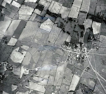
The image is an
aerial view of the
village of Gillberga
with all the strips of
acres and meadows
around the village.
Image: Kalmar Läns
Museum. ID:
KLMF.D00054.
Tegskifte is a generic
term for the various ancient forms of division -
usually in narrow strips, so-called tegar - of fields and
meadows between the various farms within the
common boundaries of the villages. The strips of
tilled land were mixed, i.e. they were more or less
systematically mixed and cultivated individually by
their owners in an annual rhythm common to the
village community. The solskifte (sun system) was a
systematic form of the tegskifte. The tegskifte
system, which was common before the reforms of
the 18th and 19th centuries, gave the farms a share
in all the different types of land and soil in the
village. It was not until the enskifte (single parcel
system) and the laga skifte that the fertility of the soil
was weighed against the size of the surface of the
parcels when implementing the land reforms.
Solskiftet
The Solskifte System was a land tenure system
that developed in the early middle ages but was
formalized in Swedish law around 1350. Solskifte
means Solar distribution of farmland and is a way of
allocating land within the community, such that each
farmer gets equal access to the sun through the
year.
The Solskifte meant the laying out of rectangular
farming village plots as single or double terraced
villages. The width of the farm plot was determined
by the size of the farm or its share in the village. The
farm that was located first in the village always had
the first strip of tilled land in the acres in the same
relative position as the farm plot in the village, hence
the name 'solskifte'. The farm whose plot was
furthest to the south thus also had its strips to the
south in each strip of the tilled land. Solskiftet
referred to both cultivated land and the
redistribution of the previously common land of
fields and meadows.
These strips of tilled land were common in eastern
Central Sweden, where the width and order of the
rows followed an agreed pattern. The Uppland Law
stipulates Solskifte and in Magnus Eriksson's
National Law Code of 1350, it is laid down for the
whole of Sweden, although in practice it never
spread outside Central Sweden.
Solskifte got its name from the principle of order
that applied when the strips of tilled land were laid
out: each farm got its strip in the same relative
position as the farm plot in the village so that the
farm whose plot was furthest south or east on the
village plot also got its strips in the south and east in
each set of strips.
In this method of tenure, a community was
composed of a village and the surrounding lands.


Agricultural Land Reforms,
Sweden (1)
Storskifte Land Reform in 1749
and 1757
The first modern land reform in Sweden was the
"storskifte" (The Great Land Reform or The Great
Partition / The Great Land Redistribution).
Storskifte was a land reform supported by the
government enabling the division of the farmland of
the village communities, from the former Solskifte
system to a new system, where every farmer in the
village was to own connected pieces of farmland
instead of several scattered strips of land.
Under the law of 1734, a new division or
redistribution of the farmland could not take place
unless all the landowners in the village agreed to it.
The land reform was initiated by the Riksdag
(Parliament) with the 1749 Land Survey Act, and later
in 1757 with a decree called the "Storskifte", which
introduced the "land reform warrant" (i.e. the land
reform was to be executed if one landowner in the
village requested it). This made it possible for a co-
owner of the village farmland to request
redistribution of land (skifte), which then also
included the other landowners' shares of the
farmland, i.e. an attempt to gather the farmers'
several strips of land into larger coherent parcels.
Storskifte was carried out in large parts of the
country between 1758 and 1827.
The land reform had two main objectives:
1.
To consolidate the fields and meadows into fewer
units.
2.
To divide the jointly owned land between the
farmers to improve its use.
In other words, the reform involved the
redistribution of land ownership in rural villages. The
target set in 1762 was a maximum of four pieces of
arable land and an equal number of meadows per
farm, but this target was not always met, not even in
later lands reforms.
From 1783, individual farms could request complete
separation and relocation from the village, a
precursor to the 1803 Enskifte land reform. Such
relocation of farmhouses (onto each farmer’s
allocated land) was preceded by a property valuation
and land grading, with the size of land weighed
against the quality of the land.
The Storskifte land reform was inspired by similar
land reform in England involving land redistribution.
Enskifte Land Reform
As can be seen from the Storskifte section above, the
goal of fewer and larger parcels was not always
achieved. King Gustav IV Adolf, therefore, issued the
Ordinance on Enskifte, which meant that each
farmer's land should be combined into one single
piece of farmland if possible. The enskifte began to
be implemented in Sweden in the late 18th and
early 19th centuries.
Enskifte was the second modern land reform and was
initiated by Rutger Macklean at the Svaneholm
estate in Skåne. Inspired by the land reforms carried
out in England and Denmark, Macklean already
implemented a major land redistribution on his
Svaneholm estate in the late 18th century, despite
strong opposition from the peasants. In several of
villages under the estate, a very strict redistribution
of land was then implemented, which meant that the
scattered land of the farming units had to be brought
together in one larger parcel, enskifte, which meant
that the old villages were split up. In many cases, the
farmers had to move their farmhouses or build new
ones within the
boundaries of the new
coherent parcels.
The image shows
Svaneholms estate in
Skurup, Skåne, in 2008.
Image: Wikipedia.
As the reform showed
that both productivity and profitability increased, a
decree was issued in 1803 by the government on the
implementation of the enskifte in the whole of
Skåne, in the county of Skaraborg in 1804 and the
whole kingdom in 1807, except for the counties of
Kopparberg, Gävleborg, Västernorrland and
Västerbotten, and Finland. In principle, the northern
parts of the country were excluded.
Some farmers had to leave their village plot to build
a new farmhouse on the allocated land, others had
the opportunity to stay. The enskifte redistribution of
farmland was not only initiated by owners of landed
estates but was also carried out in villages with
freehold farmers. A prerequisite for the success of
enskifte was that the land was equal and fertile and
that almost all the land could be cultivated. This
meant that the enskifte system was most
widespread in the plains of Skåne and Västergötland
and on Öland.
The enskifte followed the great land reform,
Storskifte, but was much more radical. It was in turn
followed by the Laga skifte reform of 1827 since the
expected results were not achieved. As the Storskifte
and the Enskifte were practiced in parallel in the
country, difficulties arose in consistently
implementing the reform of the Enskifte. Enskifte
literally means “one parcel”.
Laga skifte Land Reform in 1827
During the reign of King Karl XIV Johan, the land
reform could be carried out more systematically. In
1827, the law on the Laga skifte (Skiftesstadgan) was
passed, but it was carried out at different times
around the country. The principles of this statute
remained in force until 1928. It was partially revised
in 1866 and replaced by the 1926 Act on the division
of land, which came into force on 1 January 1928. The
name of the Act, Laga Skifte, implies that the land
reform was legally supported.
The objective of the Laga skifte was to some extent
the same as that of the reform of the Enskifte; the
aim was to combine the landowners' farmland into
as few parcels as possible. The Laga skifte
determined that a farming unit could comprise a
maximum of three parcels of land.
Every co-owner of a village could, according to the
1827 Laga skifte Act (land reform Act), request
redistribution of the parcels of land, and
redistribution could be carried out of land belonging
to a village or homestead in which two or more
people had a share. In principle, the redistribution
would cover all types of land.
At the time of the redistribution settlement, a
property valuation would be made to obtain a fair
distribution of the land. The landowner who was
allocated land of poorer quality at the time of the
land redistribution could be compensated by
receiving a larger area. The total value of the
homestead before and after the division would be
equal.
The image shows the village of Väsby in Östergötland
in 1898. The strips of tilled land in this village have
not been redistributed in the land reforms as can
been seen in the photo. Image: Wikipedia.
For all farmers to receive their rightful share of the
land, previously uncultivated land also had to be
distributed among the farmers, which for many
meant labor-intensive new cultivations. To cultivate
the new land, some farmers were required to move
out (utflyttningsskyldighet), which meant moving the
farm (farmhouse, outbuildings, etc.) from the village
plot. Many of the village farmhouses, X-joint
loghouses, were therefore dismantled and rebuilt on
the location of the respective farmer’s newly
allocated land.
As farms were relocated, the village centers were
broken up, i.e. split. However, some farms remained
in their original location.
The land redistribution including the relocation of
farms meant that farmers no longer were dependent
on each other in the same way as they previously
been in the villages, and they no longer had to cross
someone else's field to get to their own.
In parts of Sweden, the land reform was never
carried out, especially not in Dalarna.
When land redistribution was to be carried out in a
village, a land surveyor was sent to measure the
farmers' land, distribute it, and draw up land
redistribution maps (skifteskartor).
However, many farmers did not want to know about
any redistribution of the parcels. It is said that in
some cases the peasants were so angry with the
surveyors that they had to carry a gun to protect
themselves.
Disputes concerning the distribution of parcels were
to be dealt with in the first instance by a newly
created court, the Property-Dividing Court
(Ägodelningsrätten).
In 1970, the 1926 Land Division Act was replaced by
the Land Consolidation Act, which entered into force
on 1 January 1972. This abolished the concept of
"Laga skifte" in Swedish property law.
Summary
The Storskifte land reform brought about a
redistribution of farmland and meadows to fewer,
larger coherent acres. The Enskifte land reform
means that an attempt was made to combine the
landholdings of each farm into a single unit, a single
parcel of land. The Laga skifte meant combining the
landowners' farmland into as few parcels of land as
possible.
The Storskifte covered only the village's infields
(inägomark), i.e. the fields and meadows closest to
the village. The outlying fields (Utmarken), often in the
form of a wooded pasture, were to be retained as
jointly owned land.
Usually, it is the boundaries from the Laga skifte that
we can see around today’s countryside.
Land Redistribution Maps
Land redistribution maps (land surveying maps) were
drawn up in connection with the land distribution of
farmland in each village. The oldest hand-drawn
maps were produced in only one copy each.
The National Land Survey of Sweden (Lantmäteriet)
later established regional offices and then the
instruction was changed, so that the surveyor, from
the basic or concept map he had drawn up, was
obliged to make a fair copy - a so-called renovation.
The fair copy of the drawing was to be delivered to
the central office in Stockholm for review. Most
survey files/maps were produced in triplicate.
The first copy was kept at the regional agency under
the term “concept”. The second copy remained with
the owner/village council (Byalaget) and the third
copy - the renovation - was sent to the central agency
in Stockholm for review. The village depended on
receiving the redistribution maps and documents.
Each shareholder in the village also received extracts
of the map and partition description relating to his
lot.
There are many documents left in village council
coffers, farm archives, and old chiffoniers!
Map scales were usually 1:4 000 (100 m, in reality,
corresponds to 25 mm on the map) for the infield
areas (arable and meadow land) and 1:8 000 for the
outlying areas (forest land). The land redistribution
maps may look different, as no fixed templates were
used until after 1850. The land maps are based on
the village as the principle of division. The map is
accompanied by a description explaining the
numbers and lettering on it. Lower-case letters are
used to mark the old farm fields, capital letters for
the new ones. The boundaries are drawn in black
and red.
Note that the maps provide both a snapshot and an
indication of a desired future state. Red lines usually
indicate the boundaries that the redistribution is
intended to establish. Also, some roads and common
areas are intended to be constructed after the
redistribution of the land is completed. Please note
that changes due to appeals may occur!
The land redistribution documents contain
minutes, listing the names and residences of those
present, and annexes, including appeals, and a
description of the redistribution. It shows how the
land was distributed before the division, the grading
of the farmland, and the description of the division of
the various letters (capital letters) of the new parcels.
The various colors on the maps represent different
types of land (soil). Fields tend to be yellow, pastures
light green, meadows dark green and, water blue.
There are some variations on this and therefore you
should check with what the description says. There
you can make sure which colors represent which
types of land.
The numbers on the map: the farmlands on the
map are subdivided into smaller parts depending,
among other things, on soil conditions such as
moisture, fertility, etc. Each such area has a number
and that number refers to the charts that appear in
the description of the map.
The Land Survey Agency (Lantmäteriet) has an
extensive archive of maps drawn up during the
various land reforms carried out in Sweden from the
mid-18th century to the early 20th century. The maps
and their accompanying texts are decision-making
documents that are still partly relevant today.


Related Links
•
Terminology - Land reforms
•
Land Redistribution Maps, Laga Skifte, Kumla
village, 1833, Toresund Parish
•
Agricultural Yields and Years of Famine
•
The Old Agricultural Society and its People
•
The Concept of Mantal etc.
•
Landownership - Farmers & Crofters
•
Crofts and Crofters
•
Summer Pasture
•
The "Statar" system (keeping farm laborers
receiving allowance in kind)
•
The Concept of the Socknen (parish)
•
Property Designations - Sweden
Source References
•
Skiftesreformer i Sverige; Stor-, en- och laga
skifte, Örjan Jonsson JK92/96.
•
De stora förändringarna, 23 Enskiftet och laga
skiftet.
•
Skiftenas skede, laga skiftets handlingar som
källmaterial för byggnadshistoriska studier med
exempel från Småland 1828–1927. Ander
Franzén, 2008.
•
Tegskiftet s. 112-114 i Gadd, Carl-Johan (2000).
Det svenska jordbrukets historia. Kapitel 8, Band
3, Den agrara revolutionen : 1700-1870.
Stockholm: Natur och kultur/LT i samarbete med
Nordiska museet och Stift. Stiftelsen Lagersberg.
•
Bilden av skiftet måste nyanseras, artikel i
tidningen Populär Historia i september 2003 av
Fredrik Bergman, Larserik Tobiasson.
•
Skiftena förändrade Sverige, artikel i tidningen
Släkthistoria i mars 2017 av Therese Safstrom.
•
Lantmäteriet (The National Land Survey of
Sweden)
•
Wikipedia
•
Nationalencyklopedin (Swedish National
Encyclopedia)
•
SAOB (Svenska Akademins Ordbok - The
Swedish Academy Dictionary)
Top of Page